


A WIND CHILL ADVISORY is in effect for most of central and eastern Montana until 11am Tuesday. Wind chills as low as -20° to -45° are possible.

A WINTER STORM WARNING is in effect for western Montana from 5am Wednesday until 11am Thursday. In the lower elevations, 7 to 16 inches of snow accumulation is possible. In the mountains, 12 to 24 inches of snow accumulation is possible.
A WINTER STORM WATCH is in effect for portions of western Montana from 5am/5pm Wednesday until 11am Thursday. In the lower elevations, 1 to 10 inches of snow accumulation is possible. In the mountains, 12 to 24 inches of snow accumulation is possible.
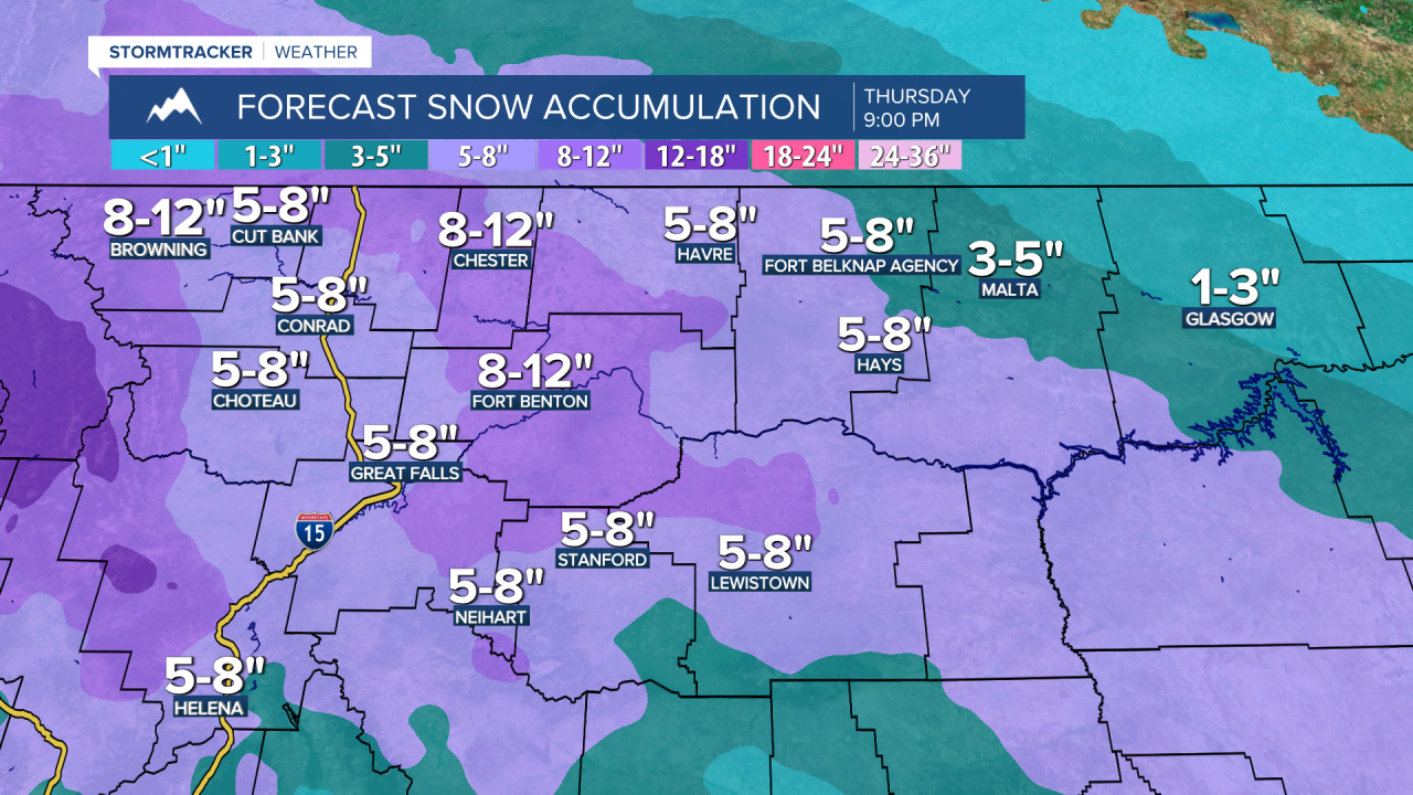
A WINTER STORM WATCH is in effect for most of north-central Montana and portions of south-central Montana from 11pm Tuesday until 5am/11am/5pm Thursday. In the lower elevations, 4 to 10 inches of snow accumulation is possible. In the mountains, along the southern Rocky Mountain Front, and in the East Glacier area, 7 to 18 inches of snow accumulation is possible.

We are going to have increasing clouds from west to east tonight. It is also going to be frigid again tonight as lows are going to be in the -0s, -10s, and -20s, but in several locations, these low temperatures will occur early tonight, with the temperatures warming up as the night goes on. It is also going to be breezy in some areas tonight as sustained wind speeds are going to be between 10 and 20 mph, and blowing snow will be an issue in some areas.
For tomorrow, we are going to have mostly cloudy skies with scattered snow showers around, mainly during the afternoon and evening and especially in north-central Montana, as a disturbance begins to impact our area. It is also going to be a lot warmer tomorrow than it has been here of late as highs are going to be in the teens and 20s in most locations. There is also going to be a breeze around in some areas tomorrow as sustained wind speeds are going to be between 10 and 20 mph, and there will be some blowing snow around.
There are then going to be areas of snow around tomorrow night, with periods of snow expected on Wednesday, and some of this snow may be moderate to heavy at times. Widespread snow is then likely Wednesday evening and Wednesday night as a strong storm system passes through our area, and some of this snow may be moderate to heavy at times. There are then going to be scattered snow showers around Thursday morning as this storm system departs our area. The skies will also begin to clear out on Thursday.
In north-central and central Montana, this is going to be the biggest snowstorm that we have had since last October. In the lower elevations, 4 to 10 inches of snow accumulation is expected in most locations, with lower amounts (coating to 5 inches) expected in northeastern Montana. In the mountains as well as along the southern Rocky Mountain Front and in the East Glacier area, 7 to 18 inches of snow accumulation is expected, with isolated higher amounts possible on the highest peaks. This snow will create difficult travel conditions, so please use caution when driving and give yourself some extra time to get to where you need to go.
The temperatures are also going to cool back down on Wednesday and Thursday as highs on Wednesday are going to be in the single digits and low to mid teens, and highs on Thursday are going to be in the 0s and -0s.
On Friday, we are going to have mostly cloudy skies with some isolated snow showers around, especially in the mountains, as a disturbance passes through our area. Some isolated snow and rain showers are also possible on Saturday, especially in the mountains, as another disturbance passes through our area. We are also going to have mostly cloudy skies on Saturday. The temperatures are also going to warm up a lot over these two days as highs are going to be in the single digits, teens, and low to mid 20s on Friday and the mid to upper 20s, 30s, and low 40s on Saturday. It is also going to be breezy on Saturday as sustained wind speeds are going to be between 10 and 20 mph.
Partly cloudy skies and mainly dry conditions are then expected on Sunday and Monday as high pressure is going to be in control of our weather. We are also going to have above average temperatures on these two days as highs are going to be in the 30s and low to mid 40s. It is also going to be breezy in some areas on these two days as sustained wind speeds are going to be between 10 and 20 mph.


