

A WINTER WEATHER ADVISORY is in effect for the Glacier area and the Rocky Mountain Front until 11am/5pm Saturday.

A COLD WEATHER ADVISORY is in effect for part of northeastern Montana near the Canadian border from 2am until 9am Saturday.

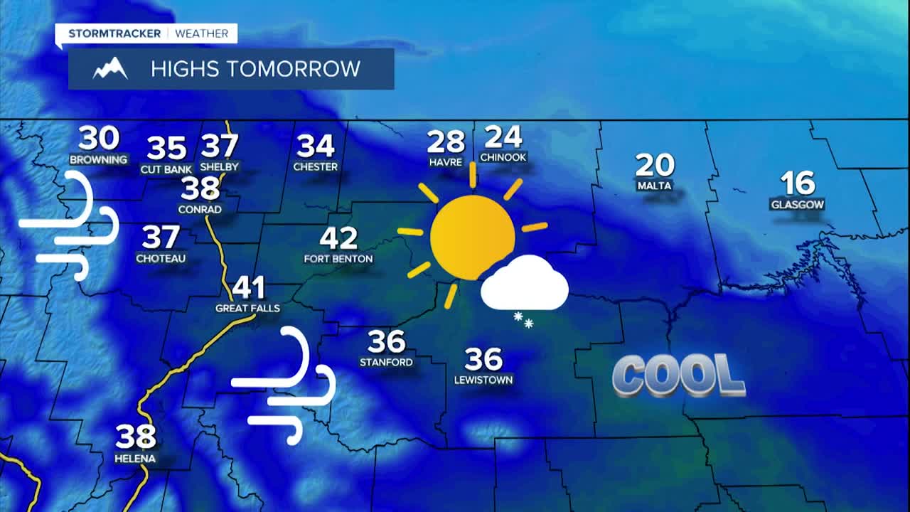
It was another windy day today as peak wind gusts were between 40 and 70 mph, but the wind today was not nearly as strong as it was on Wednesday. Gusty winds will continue through tomorrow in western and southern portions of north-central Montana as 10-30 mph sustained winds are expected, and wind gusts over 40 mph will be possible at times. Around Helena, it will be a little breezy (5-15 mph) tonight and breezy (10-20 mph) tomorrow. Elsewhere, there will be just a little breeze around tonight and tomorrow.


Snow will continue to fall tonight and tomorrow in Glacier National Park and along the Divide. 2-6” of new snow is possible at and below pass level, and up to 10” of new snow is possible above pass level. In north-central Montana and around Helena, we are going to have mostly clear skies tonight with a few isolated snow showers around, generally along the eastern half of the Hi-Line. Tomorrow will be mostly sunny and mostly dry.
Here is the weekend forecast:
It is going to be cold tonight along the Hi-Line as lows are going to be in the single digits and teens. South of the Hi-Line, it is going to be chilly tonight as lows are going to be in the teens and 20s. Tomorrow will be a chilly day along the eastern half of the Hi-Line as highs are going to be in the 20s and mid to upper teens. Elsewhere, it is going to be cool tomorrow as highs are going to be in the 30s and low 40s.
Sunday will be partly to mostly cloudy, with the cloud cover increasing as the day goes on. Most will stay dry on Sunday, but isolated rain and snow showers are possible around Helena and Lewistown during the evening. It will be breezy (10-25 mph) on Sunday along the Rocky Mountain Front, but elsewhere, there will be little to no wind. It is also going to feel nice outside on Sunday as highs are going to be in the 30s and low to mid 40s.
Scattered rain and snow showers are expected around Helena Sunday night into Monday morning and there will be a few rain and snow showers around in north-central Montana as a disturbance passes through our area. We are also going to have partly to mostly cloudy skies on Monday.
Tuesday and Wednesday will be mostly cloudy and mostly dry, just a few isolated rain and snow showers around, generally in the mountains. We are then going to have partly cloudy skies on Christmas Day with a few isolated rain and snow showers around. Right now, it looks like most of central and north-central Montana will have a brown Christmas this year.
It will be cool along the Hi-Line from Monday through Wednesday as highs are going to be in the 30s and upper 20s. It will be mild south of the Hi-Line from Monday through Wednesday as highs are going to be in the 40s and low 50s. The temperatures will then cool down some for Christmas Day as highs are going to be in the 20s and 30s. The wind also won’t be too bad next week, but it will be a bit breezy in some areas Monday, Wednesday, and Thursday as sustained wind speeds are going to be between 10 and 20 mph.


