We are going to have mostly clear skies and mild temperatures tonight as lows are going to be in the 40s and low 50s in most locations. The wind is also going to increase later on tonight along the Rocky Mountain Front.
A disturbance will bring gusty winds to our area tomorrow as sustained wind speeds are going to be between 10 and 30 mph, and wind gusts up to 40 mph are possible. Along the Rocky Mountain Front, it is going to be windy tomorrow as sustained wind speeds are going to be between 20 and 35 mph, and wind gusts up to 60 mph are possible. A few isolated showers and thunderstorms are also possible tomorrow afternoon/evening, mainly south and east of Helena, in northeastern Montana, and in Fergus County and Judith Basin County. Dry conditions are expected elsewhere. We are also going to have mostly sunny skies and a wide range of temperatures tomorrow as highs are going to range from the mid 60s near the Divide to the mid 80s in northeastern Montana.
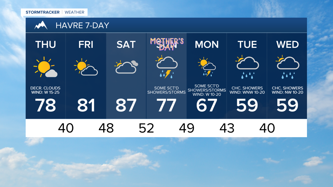
On Friday, we are going to have fabulous weather as we are going to have partly to mostly sunny skies, dry conditions, and warm temperatures as highs are going to be in the mid to upper 70s and low to mid 80s. There is also going to be less wind around on Friday as it is just going to be a little breezy in most locations with sustained wind speeds between 5 and 20 mph.
It will be another warm weekend as highs are going to be in the 80s and low 90s on Saturday and the 70s and mid to upper 60s on Sunday. On Saturday, we are going to have partly to mostly cloudy skies with some isolated showers and thunderstorms around during the evening, especially around Helena. There are then going to be scattered showers and thunderstorms around on Sunday, generally during the PM hours. We are also going to have mostly cloudy skies on Sunday. There is also going to be a bit of a breeze around this weekend as sustained wind speeds are going to be between 10 and 20 mph.
An upper-level trough will then bring cooler and wetter weather to our area for next week. On Monday, we are going to have partly cloudy skies with scattered showers and thunderstorms around. We are then going to have a chance to see some more showers on Tuesday and Wednesday. We are also going to have mostly cloudy to overcast skies on these two days.
Cooler temperatures are also expected next week as highs are going to range from the mid 50s to the mid 70s on Monday, and highs are going to be in the 50s and low 60s in most locations on Tuesday and Wednesday. There is also going to be a bit of a breeze around on these three days as sustained wind speeds are going to be between 10 and 20 mph.