We are going to have mostly clear skies and cool temperatures tonight as lows are going to be in the mid to upper 20s and low to mid 30s in most locations. It is also going to be breezy tonight along the Rocky Mountain Front as sustained wind speeds are going to be between 10 and 20 mph. Elsewhere, it is going to be a little breezy tonight as sustained wind speeds are going to be between 5 and 15 mph.
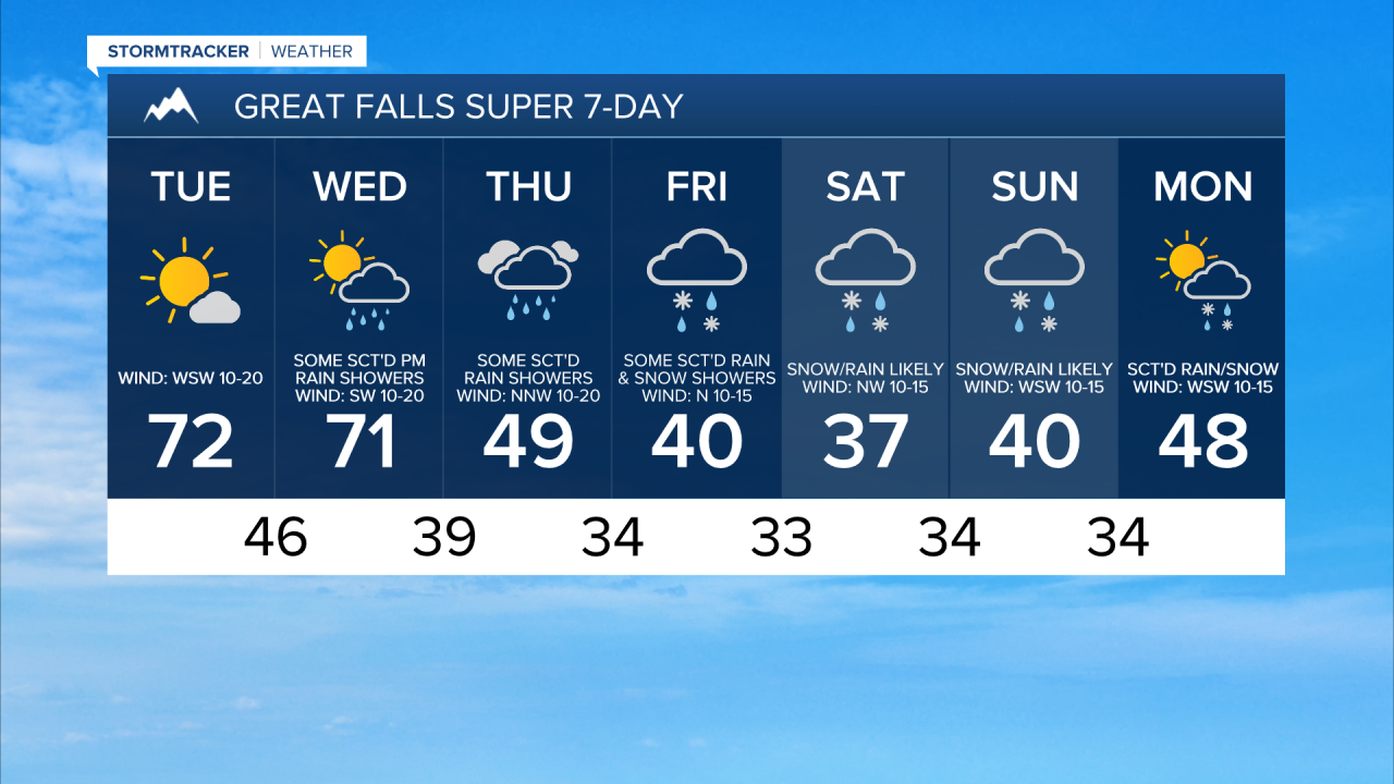
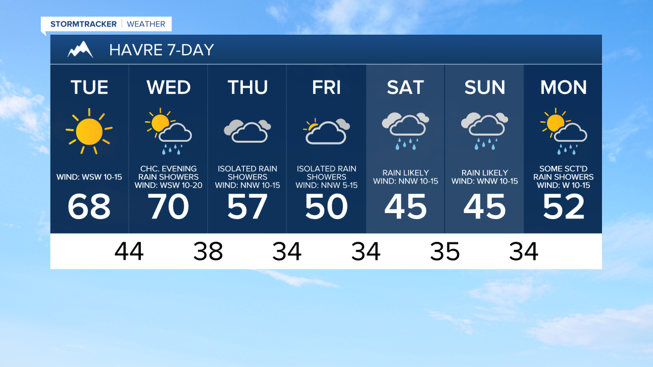
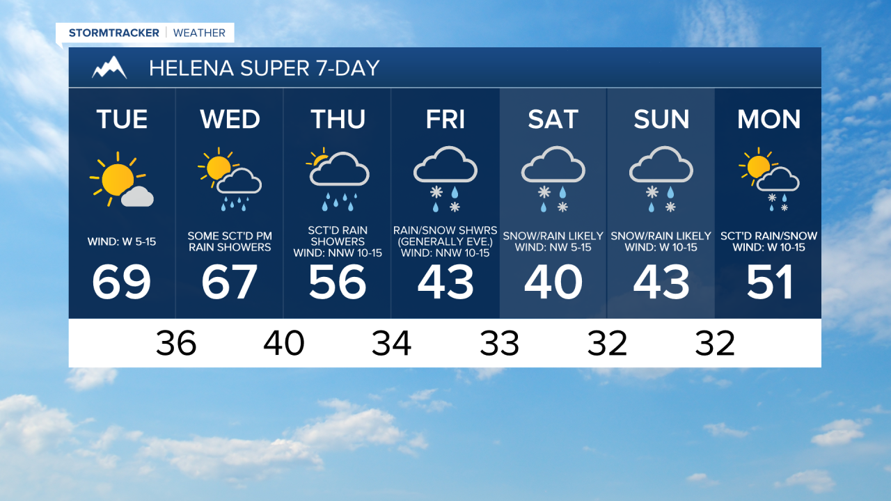
For tomorrow, we are going to have beautiful weather as we are going to have mostly sunny skies, dry conditions, and warmer temperatures as highs are going to be in the upper 50s, 60s, and low 70s in most locations. Gusty winds are also expected tomorrow along the Rocky Mountain Front as sustained wind speeds are going to be between 15 and 30 mph. Elsewhere, it is going to be breezy tomorrow as sustained wind speeds are going to be between 10 and 25 mph.
On Wednesday, we are going to have increasing clouds with some scattered rain showers around, mainly during the afternoon and evening, as an upper-level trough begins to impact our area. It is also going to be warm again on Wednesday as highs are going to be in the 60s and low to mid 70s in a lot of locations. There is also going to be a breeze around in some areas on Wednesday as sustained wind speeds are going to be between 10 and 25 mph.
There are then going to be some scattered showers around on Thursday and Friday, especially along the Rocky Mountain Front, along the I-15 corridor, and around the Helena area. In the lower elevations, this precipitation will generally be in the form of rain, but some snow is possible, especially along the Rocky Mountain Front and in the Glacier County area. In the mountains, this precipitation will generally be in the form of snow, but a little rain may mix in at times, especially on Thursday. We are also going to have mostly cloudy to overcast skies on these two days.
It is also going to be breezy in some areas on these two days as sustained wind speeds are going to be between 10 and 20 mph. We are also going to have a wide range of temperatures on these two days, with the temperatures cooling down some between the two days. On Thursday, highs are going to range from the mid 30s to the low 70s, and on Friday highs are going to range from the low 30s to the upper 60s, with the coolest temperatures on both days along the Rocky Mountain Front and the warmest temperatures on both days in eastern Montana.
Sloppy weather is then expected this weekend as an upper-level trough is going to be in complete control of our weather. Snow is likely this weekend in the mountains, and there are going to be areas of rain and snow around this weekend in the lower elevations. There is still a lot of fluctuation with the models on how much of the precipitation will fall as rain versus snow in the lower elevations, so stay tuned to KRTV/KXLH as the week goes on as we fine-tune who will see rain versus snow and how much snow accumulation is possible. We are also going to have mostly cloudy to overcast skies this weekend.
It is also going to be chilly this weekend as highs are going to be in the 30s and 40s in most locations (50s in eastern Montana). There is also going to be a bit of a breeze around in some areas this weekend as sustained wind speeds are going to be between 10 and 20 mph.
There are then going to be scattered areas of rain and snow around on Monday as this upper-level trough begins to leave our area. We are also going to have partly cloudy skies and warmer temperatures on Monday as highs are going to be in the 40s and low to mid 50s in most locations.