


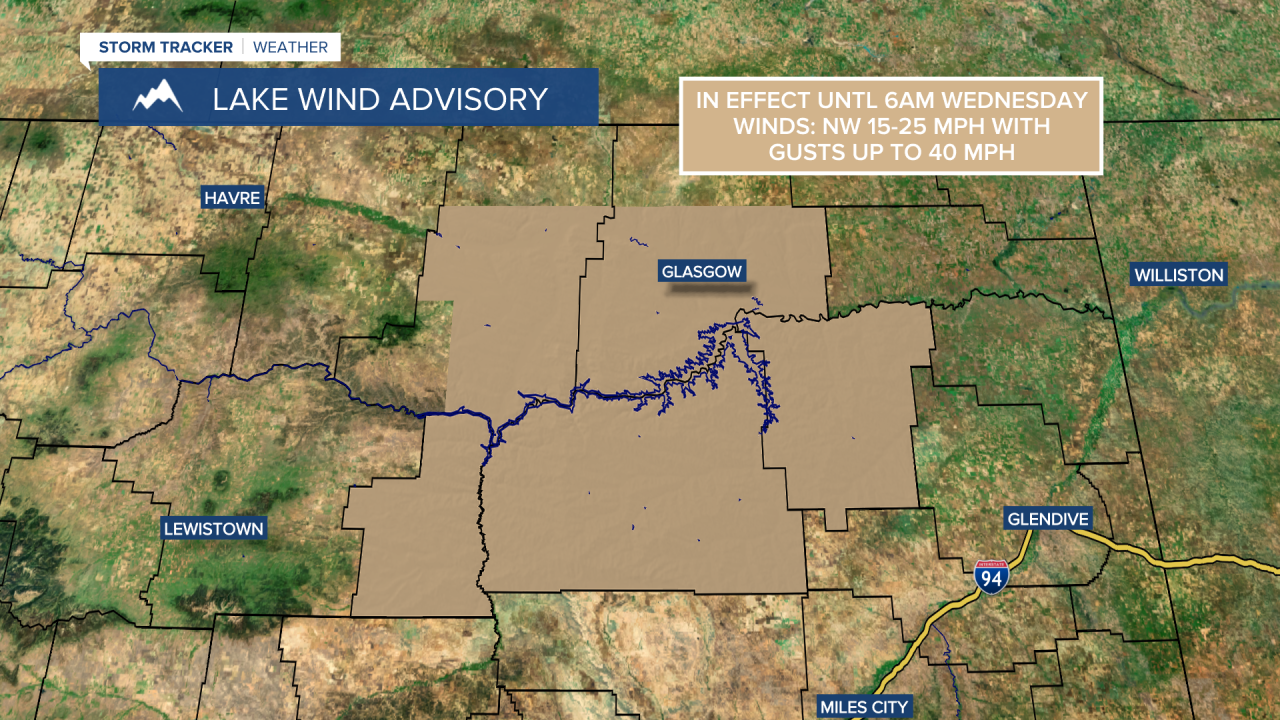
In eastern Montana, we are going to have mostly cloudy skies tonight with a few scattered light rain showers around. In central Montana, we are going to have decreasing clouds tonight with some scattered light valley rain and mountain rain/snow showers around, mainly during the evening. It is also going to be breezy tonight, especially before midnight, as sustained wind speeds are going to be between 10 and 25 mph. A Lake Wind Advisory also remains in effect until 6am tomorrow morning for Fort Peck Lake. There are also going to be some areas of frost around tonight in central Montana as lows are going to be in the mid to upper 30s and low 40s in most locations. In eastern Montana, it is going to be cool tonight as lows are going to be in the mid to upper 40s in most locations.
For tomorrow, we are going to have partly cloudy skies in eastern Montana and mainly sunny skies in central Montana. Mainly dry conditions are also expected tomorrow. It is also going to be cool and breezy tomorrow as highs are going to be in the 60s in most locations, and sustained wind speeds are going to be between 10 and 20 mph.
It is then going to be chilly again tomorrow night as lows are going to be in the upper 20s and low to mid 30s in most locations. There are also going to be widespread areas of frost around tomorrow night, so make sure you take the necessary precautions to protect any sensitive plants/vegetation that you may have. We are also going to have mainly clear/hazy skies and dry conditions tomorrow night.

We are then going to have lots of sunshine, hazy/smoky skies, dry conditions, and warmer temperatures on Thursday as highs are going to be in the upper 60s and low to mid 70s in most locations. It is also going to continue to be a bit breezy on Thursday, especially during the afternoon and evening, as sustained wind speeds are going to be between 10 and 20 mph.
On Friday, we are going to have increasing clouds with some scattered rain showers around, generally during the afternoon and evening, as a storm system begins to approach our area. We are then going to have decreasing clouds with a chance of a few valley rain and mountain rain/snow showers on Saturday as this storm system departs our area. It is also going to be cool on these two days as highs are going to be in the mid to upper 60s and low 70s in most locations.
Lots of sunshine and dry conditions are then expected on Sunday, Monday, and Tuesday as high pressure is going to be in control of our weather. It is also going to feel really nice outside on these three days as highs are going to be in the 70s in most locations.


