An Air Quality Alert is in effect for all of Montana until at least 9am tomorrow morning as the air quality tonight is generally going to be in the “unhealthy for sensitive groups” category.

A Red Flag Warning is in effect for all locations east of the Continental Divide until midnight tonight as new or currently burning wildfires may grow and/or spread rapidly due to the combination of low relative humidity, gusty winds, and hot temperatures.

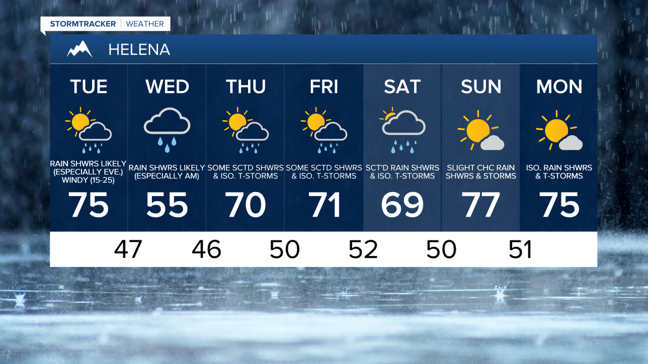
For tonight, we are going to have mostly clear skies with some isolated rain showers and thunderstorms around. It is also going to be mild tonight as lows are going to be in the mid to upper 50s and low 60s in most locations. Breezy conditions are also expected this evening as sustained wind speeds are going to be between 10 and 25 mph.
A strong cold front is then going to pass through our area tomorrow from the northwest to the southeast. This cold front is going to bring some much cooler air to our area as highs tomorrow are going to range from the 60s and 70s in central Montana to the 80s and 90s in eastern Montana. Highs on Wednesday are then only going to be in the low to mid 50s in central Montana and the mid to upper 60s in eastern Montana. Windy conditions are also expected tomorrow as sustained wind speeds are going to be between 15 and 25 mph, and wind gusts up to 50 mph are going to be possible at times. It is then going to be breezy/windy tomorrow night and breezy on Wednesday as sustained wind speeds are going to be between 10 and 25 mph, and wind gusts up to 40 mph are going to be possible at times.
This cold front and its associated storm system are also going to bring widespread precipitation to our area tomorrow and Wednesday. Showers are going to gradually develop throughout the day tomorrow, with rain likely in most locations in central Montana tomorrow evening, tomorrow night, and Wednesday morning. The rain showers are then going to gradually taper off Wednesday afternoon and evening. Many locations in central Montana are going to pick up at least 0.50” of precipitation from this storm system, and some locations may even pick up over an inch of precipitation by the time this storm system leaves our area. Some snow is also going to be possible tomorrow night and Wednesday morning in the peaks of the Rockies. Eastern Montana is going to miss out on most of this rain, but up to 0.25” of rainfall is still possible by Wednesday evening.
We are then going to remain in a cooler and wetter weather pattern for the end of the work week and the first half of the weekend. From Thursday through Saturday, there are going to be some scattered rain showers and isolated thunderstorms around as multiple disturbances pass through our area. The high temperatures on these three days are also going to be well below average for this time of year as highs are only going to be in the mid to upper 60s and low 70s in most locations.
The temperatures are then going to warm up some on Sunday and Monday as highs are going to be in the mid to upper 70s in most locations. We are also going to have partly cloudy to mostly sunny skies with a chance of rain showers and thunderstorms on these two days.