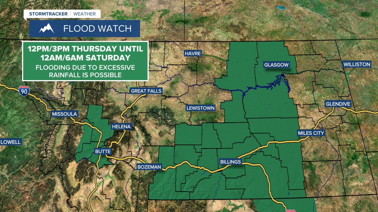
A FLOOD WATCH is in effect for portions of southern and eastern Montana from 12pm/3pm Thursday until 12am/6am Saturday. Flooding due to excessive rainfall is possible.
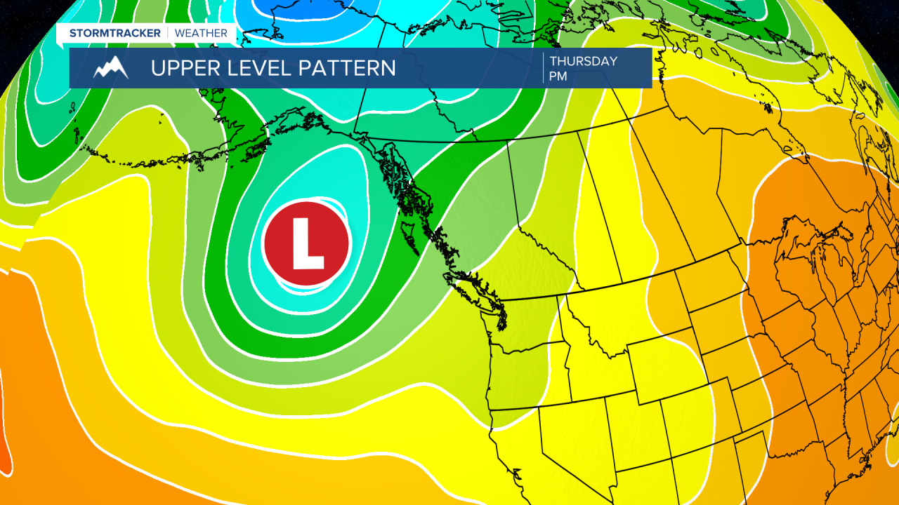
As we go through the rest of the work week, an upper-level trough near the Gulf of Alaska is going to strengthen and slowly shift towards the southeast. This upper-level trough has been and will continue to provide us with a moist and unstable southwesterly/southerly flow aloft, which is going to allow multiple disturbances with precipitation to continue to impact our area. This trough will weaken a bit this weekend, but the wet weather will likely continue.
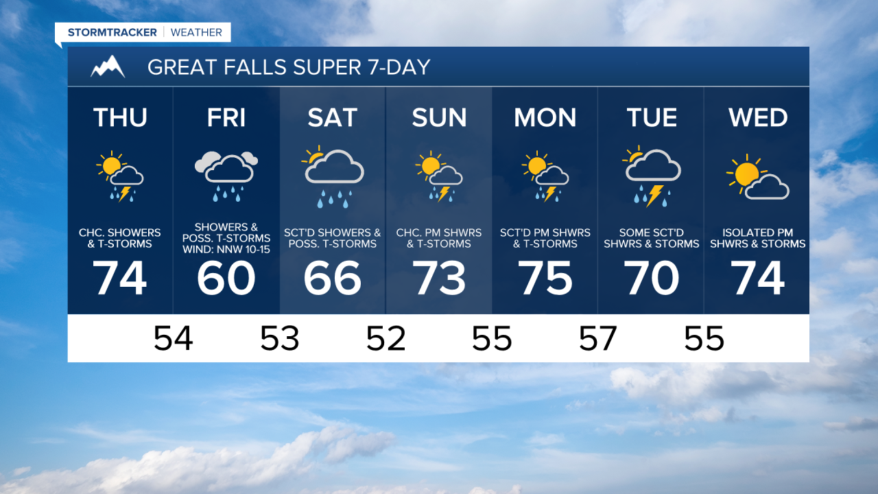
There are going to be scattered showers and thunderstorms around this evening and tonight, especially before midnight, as a disturbance passes through our area. We are also going to have mostly to partly cloudy skies and pleasant temperatures tonight as lows are going to be in the 50s and mid to upper 40s in most locations.
For tomorrow, we are going to have partly to mostly cloudy skies with some scattered showers and thunderstorms around, generally during the afternoon and evening. We are also going to have a wide range of temperatures tomorrow as highs are going to range from the upper 60s to the mid 80s, with the warmest temperatures in northeastern Montana. There is also going to be a little breeze in spots tomorrow as sustained wind speeds are going to be between 10 and 15 mph.
Scattered showers and thunderstorms will gradually transition into a larger area of stratiform rain tomorrow night. There is then going to widespread rain around on Friday in the central part of the state and this rain will persist through the afternoon before it starts to taper off. Scattered showers and thunderstorms are also going to develop Friday afternoon/evening in eastern Montana. Some of the rain that falls tomorrow night and Friday may also be heavy at times, which is why portions of Montana are under a slight risk to see excessive rainfall, as this rain may lead to some minor flooding.

It is also going to be a lot cooler on Friday as highs are going to be in the mid to upper 50s and low to mid 60s in most locations. There is also going to be a bit of a breeze around on Friday as sustained wind speeds are going to be between 10 and 20 mph.
On Saturday, there are going to be scattered showers and a few thunderstorms around, especially in locations east of I-15, as Friday’s disturbance lingers around our area. We are also going to have mostly cloudy skies and comfortable temperatures on Saturday as highs are going to be in the 60s and low 70s in most locations.
We are then going to have partly cloudy skies on Sunday with some scattered showers and thunderstorms around during the afternoon and evening as another disturbance impacts our area. It is also going to be warmer on Sunday than it is going to be on Friday and Saturday as highs are going to be in the 70s in most locations.
More scattered showers and thunderstorms are then expected on Monday and Tuesday as a couple more disturbances pass through our area. We are also going to have increasing clouds on Monday and mostly cloudy skies on Tuesday. The temperatures are also going to cool down a little bit between these two days as highs on Monday are going to be in the 70s in most locations and highs on Tuesday are going to be in the mid to upper 60s and low to mid 70s in most locations.
On Wednesday, we are going to have partly cloudy skies with a chance of PM showers and thunderstorms. We are also going to have mild temperatures on Wednesday as highs are going to be in the 70s in most locations.