A High Wind Warning remains in effect for the Rocky Mountain Front and all of Glacier County until 3pm Thursday. Sustained wind speeds are going to be between 30 and 45 mph, and wind gusts up to 70 mph are going to be possible at times.

There is also a Red Flag Warning in effect for part of north-central Montana until 5pm Thursday. Strong winds are going to make it hard to contain any new or currently burning fires.

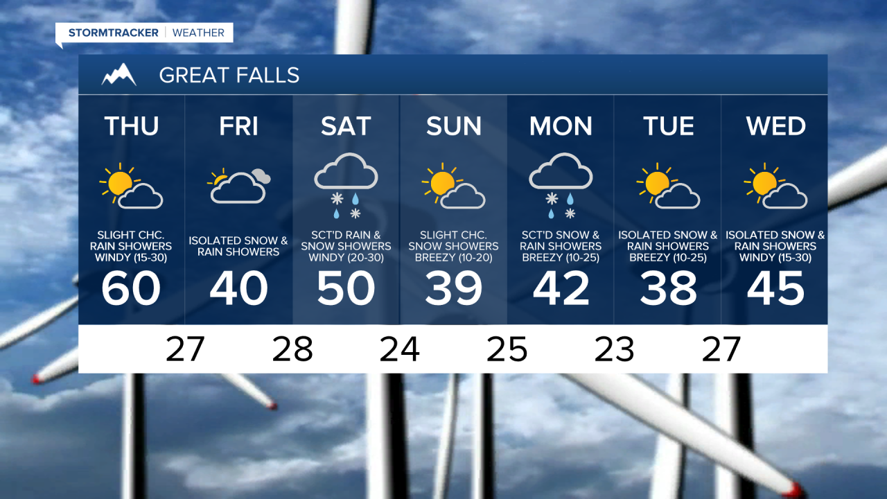
It definitely did not feel like the first day of December today. We had strong winds, multiple wildfires, and record-breaking high temperatures, not just for December 1st, but for the entire month of December! Thankfully, less wind, cooler temperatures, and some precipitation is in the extended forecast.
It is still going to be windy/breezy tonight and tomorrow, but the wind tonight and tomorrow is going to be weaker than the wind today was as sustained wind speeds are going to be between 15 and 30 mph, and wind gusts up to 40+ mph are going to be possible at times. This weaker wind also means that there will be less wind damage to worry about, and the firefighters should be able to get better control of the wildfires that are still burning, specifically the Westwind fire that is burning near Denton, MT.
It is also going to be mild again tonight, specifically in locations where it is going to be windy/breezy tonight, as lows are going to be in the 40s and 50s. Where we have less wind tonight, it will be colder as lows in Blaine County, Hill County, Phillips County, and Valley County are going to be in the 30s. For tomorrow, it is going to be cooler than it was today, but it is still going to be mild as highs are going to be in the 50s and low to mid 60s. A few locations may also set a new daily record high temperature tomorrow.
We are also going to have partly cloudy skies tonight and tomorrow with a few rain and snow showers around, generally in the Rockies.
Heading into Friday, we are going to have mostly cloudy skies with some isolated snow and rain showers around, generally during the afternoon and evening. It is also going to be a lot colder on Friday than it is going to be tomorrow as highs are only going to be in the 30s and 40s. There is also going to be less wind around on Friday as sustained wind speeds are going to be between 5 and 15 mph.
There are then going to be scattered rain and snow showers around on Saturday, especially during the afternoon and evening, as a cold front begins to approach our area. We are then going to have partly to mostly cloudy skies with some isolated snow and rain showers around, generally during the morning, on Sunday as this cold front leaves our area.
The temperatures are also going to cool down some between Saturday and Sunday as highs on Saturday are going to be in the upper 40s and low to mid 50s, and highs on Sunday are going to be in the mid to upper 30s and low to mid 40s. It is also going to be windy on Saturday as sustained wind speeds are going to be between 15 and 30 mph. There is then going to be a lingering breeze around on Sunday as sustained wind speeds are going to be between 10 and 20 mph.
On Monday, there are going to be rain and snow showers around throughout the day as a storm system works its way through our area. We are then going to have a chance to see some more snow and rain showers on Tuesday and Wednesday as we continue to remain in an unsettled weather pattern. It is also going to be chilly next week as highs are only going to be in the 30s and 40s. Breezy conditions are also expected on Monday and Tuesday as sustained wind speeds are going to be between 10 and 25 mph. It is then going to be windy on Wednesday as sustained wind speeds are going to be between 15 and 30 mph.