


A HIGH WIND WARNING remains in effect until 12am Wednesday for all of central Montana and until 4am Wednesday for Phillips County and southern Valley County. Sustained wind speeds are going to be between 30 and 45 mph, and wind gusts up to 75 mph are going to be possible at times.

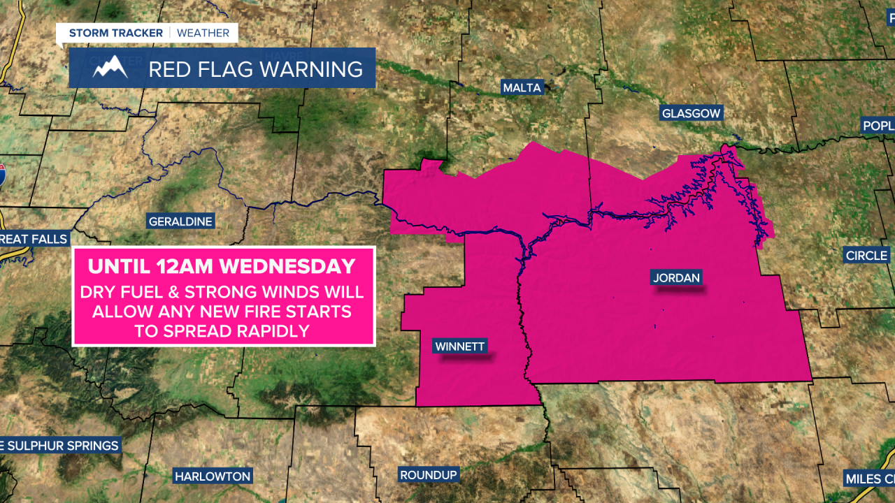
A RED FLAG WARNING is in effect for southern Phillips County and southern Valley County until 12am Wednesday. Dry fuel and strong winds will allow any new fire starts to spread rapidly.
A WINTER WEATHER ADVISORY is in effect for northern Valley County until 4am Wednesday. Up to 5 inches of total snow accumulation is possible.

The wind is going to diminish some tonight, but we are still going to have gusty winds around as sustained wind speeds are going to be between 10 and 30 mph, and wind gusts over 50 mph are going to be possible at times. There are also going to be some scattered rain and snow showers around tonight, generally in locations east of I-15, and light snow accumulations are possible in locations that see some of this snow. It is also going to be chilly tonight as lows are going to be in the mid to upper 20s and low to mid 30s.
For tomorrow, it is going to be breezy in central Montana as sustained wind speeds are going to be between 10 and 25 mph, and it is going to be windy in east-central and eastern Montana as sustained wind speeds are going to be between 15 and 30 mph. It is also going to be cool tomorrow as highs are going to be in the mid to upper 40s and low to mid 50s in most locations. We are also going to have partly cloudy skies tomorrow with a few scattered rain and snow showers around, generally in locations east of I-15.
Nice weather is then expected for the end of the work week as high pressure is going to be in control of our weather. On Thursday, we are going to have lots of sunshine, little wind, and mild temperatures as highs are going to be in the mid to upper 50s and low to mid 60s. We are then going to have partly cloudy skies and warm temperatures on Friday as highs are going to be in the mid to upper 60s and low to mid 70s. It is also going to be breezy on Friday as sustained wind speeds are going to be between 10 and 25 mph.
There are then going to be some scattered rain and snow showers around Friday night and Saturday as a cold front works its way through our area. It is also going to be windy on Saturday as sustained wind speeds are going to be between 15 and 35 mph, and wind gusts over 50 mph are going to be possible at times. The temperatures are also going to be a lot cooler on Saturday than they are going to be on Friday as highs are only going to be in the mid to upper 40s and low 50s.
Chilly temperatures are then expected on Sunday, Monday, and Tuesday as highs are only going to be in the mid to upper 30s and low to mid 40s. It is also going to be a bit breezy on these three days as sustained wind speeds are going to be between 10 and 20 mph. There are also going to be scattered areas of snow around on Sunday, and some scattered areas of snow around on Monday and Tuesday as a couple disturbance pass through our area.


