


A WIND CHILL WARNING is in effect for most of central and eastern Montana until midday Friday. Wind chills as low as 60 below zero are possible.
A WIND CHILL ADVISORY is in effect for southwestern Montana and portions of western Montana until 11am Friday. Wind chills as low as 40 below zero are possible.

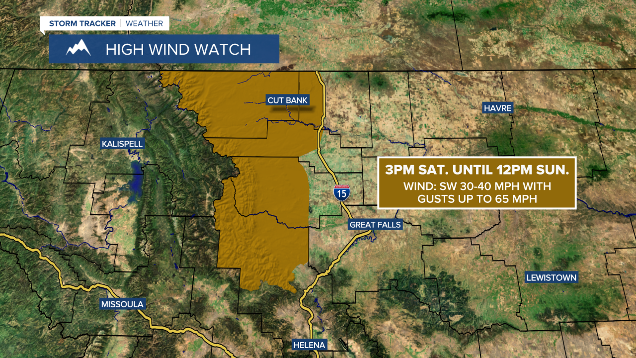
A HIGH WIND WATCH is in effect for Glacier County, northern Lewis and Clark County, western/central Pondera County, western Teton County, and western Toole County from 3pm Saturday until 12pm Sunday. Sustained wind speeds are going to be between 30 and 40 mph, and wind gusts up to 65 mph are going to be possible at times.
It is going to be bitterly cold again tonight as lows are going to be in the -20s and -30s in many locations, and wind chills are going to be in the -30s and -40s for a lot of the night. Definitely stay inside if possible. We are also going to have increasing clouds tonight with a slight chance of snow showers as we get closer to daybreak tomorrow.
For tomorrow, it is going to be warmer than it was today as highs are going to be in the -0s, 0s, and 10s in most locations, with the warmest temperatures around the Helena area. There are also going to be areas of light snow around tomorrow as a disturbance passes through our area, and light snow accumulations of a coating to a couple inches are possible. We are also going to have increasing wind tomorrow along the Rocky Mountain Front and in some of the higher elevations in central and north-central Montana.
On Saturday, we are going to have a chance to see some snow and rain showers, generally during the morning and the evening, as one disturbance leaves our area and as another disturbance begins to pass through our area. We are also going to have partly to mostly cloudy skies on Saturday. It is also going to be warmer on Saturday than it is going to be tomorrow as highs are going to be in the 20s and 30s in a lot of central and north-central Montana, although the arctic air will continue to hang around along central and eastern portions of the Hi-Line where highs are only going to be in the positive single digits.
We are then going to have partly to mostly cloudy skies on Sunday with some isolated rain and snow showers around, generally in the mountains, as Saturday’s disturbance leaves our area. It is also going to be mild on Sunday as highs are going to be in the 30s and 40s in almost all of central and north-central Montana.
Windy conditions are also expected this weekend along and just east of the Rocky Mountain Front as sustained wind speeds are going to be between 20 and 40 mph, and wind gusts up to 60 mph are going to be possible at times. It is also going to be breezy this weekend in portions of central and north-central Montana as sustained wind speeds are going to be between 10 and 25 mph, and wind gusts up to 40 mph are going to be possible at times. This wind may also cause there to be some areas of blowing and drifting snow around.
On Monday, we are going to have mostly cloudy skies and mainly dry conditions. There are then going to be some scattered rain and snow showers around on Tuesday and Wednesday, generally from Tuesday afternoon through Wednesday morning, as a disturbance passes through our area. We are also going to have mostly cloudy skies on Tuesday and decreasing clouds on Wednesday. Partly cloudy skies and mainly dry conditions are then expected on Thursday.
It is also going to continue to be breezy next week as sustained wind speeds are going to be between 10 and 25 mph, and this wind is going to be coming out of the southwest. We are also going to have above average temperatures next week as highs are going to be in the 30s and 40s, with the temperatures getting a little bit cooler as the week goes on.


