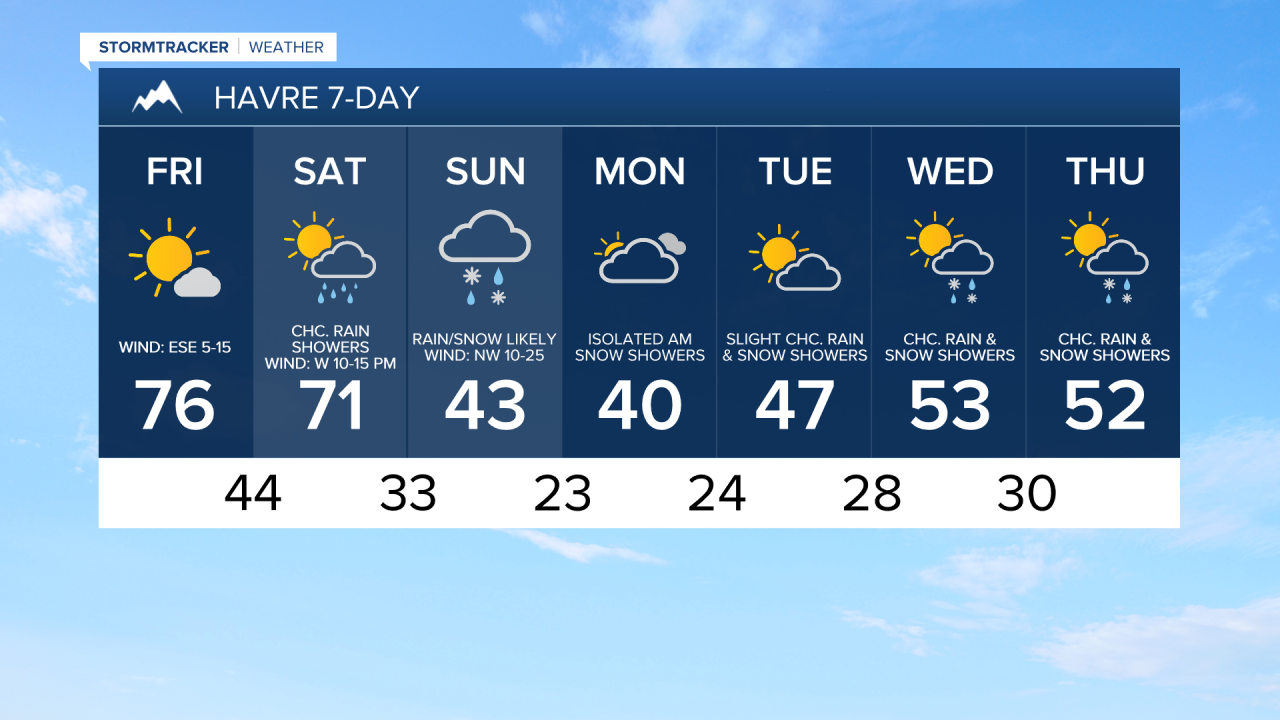
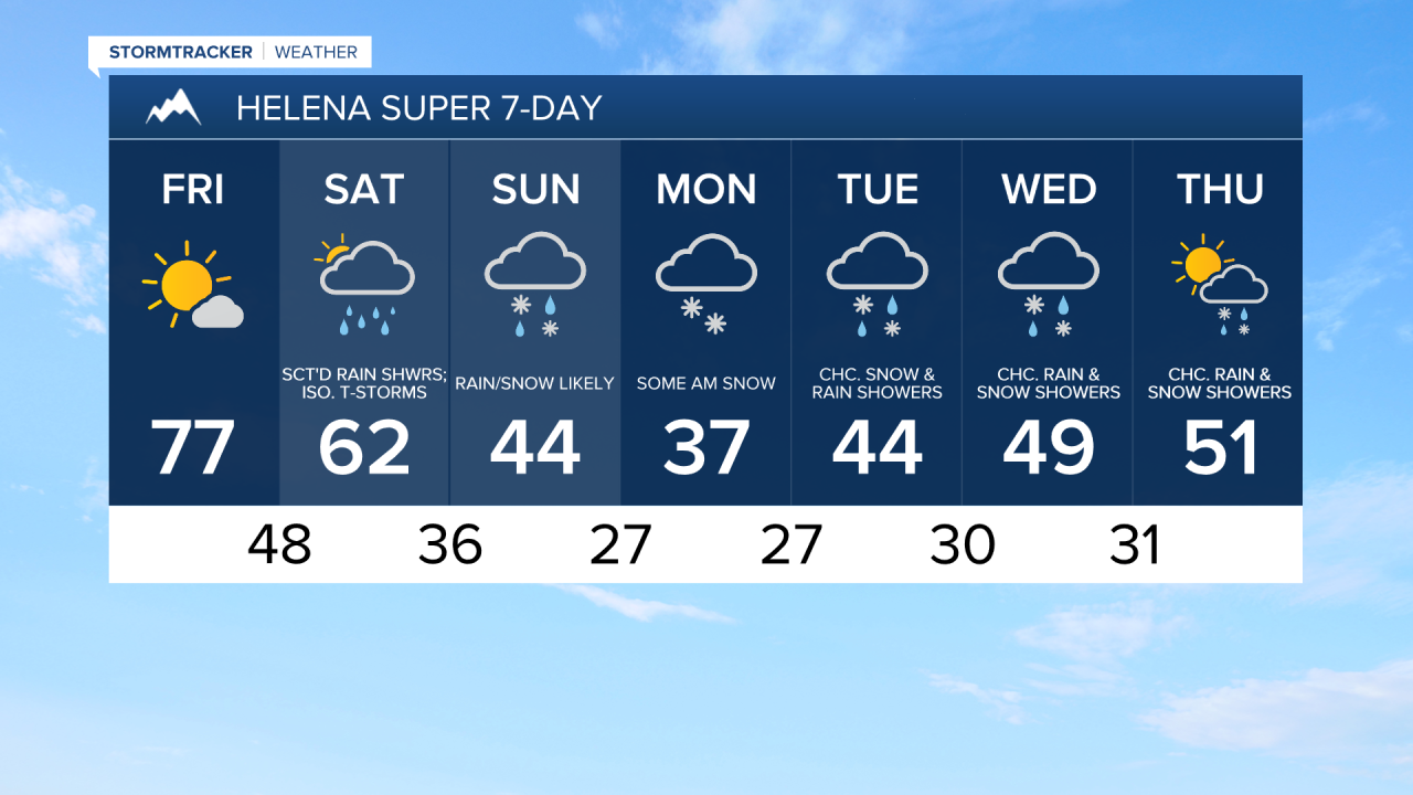
One more day of beautiful weather tomorrow before big changes arrive this weekend! Tomorrow, we are going to have mostly sunny skies, mostly dry conditions (just a few isolated showers around), and warm temperatures as highs are going to be in the 70s. Definitely spend some time outdoors tomorrow if you can! It is also going to be a bit breezy tomorrow along the eastern half of the Hi-Line and in/around the mountains in central Montana as sustained wind speeds are going to be between 10 and 20 mph.
Here is the detailed forecast:
Unsettled weather returns this weekend as an upper-level trough begins to impact our area. On Saturday, we are going to have partly to mostly cloudy skies with scattered rain showers and isolated thunderstorms around, especially during the evening, as a cold front passes through the state. This precipitation will become more widespread as we go through Saturday night and the snow levels will drop as well.
Mountain snow is then likely on Sunday and there will be areas of rain and snow around in the lower elevations, especially during the morning, as another cold front passes through the state. Snow levels on Sunday may get as low as about 3000 to 4000 feet, which means a lot of lower elevation locations will see some snow on Sunday.
There are then going to be areas of light snow around Sunday night into Monday morning in central and western Montana. As we go through Monday, that snow will taper off. We are also going to have mostly cloudy skies on Monday.
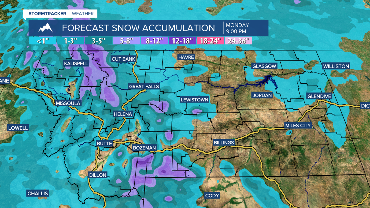
The mountains will see a good amount of snow Saturday evening through Monday morning. In Glacier National Park and along the Rocky Mountain Front, 6-12” of snow is possible above 6000 feet and 2-6” of snow is possible below 6000 feet. In the Little Belts, Highwoods, and Snowies, 4-11” of snow is possible. Due to this snow, a WINTER STORM WATCH is in effect from Saturday evening through Monday morning. Difficult travel is possible at and above mountain pass level. In the lower elevations, a coating to 3” of snow is possible through midday Monday, and it may be a slick morning commute on Monday in some areas.
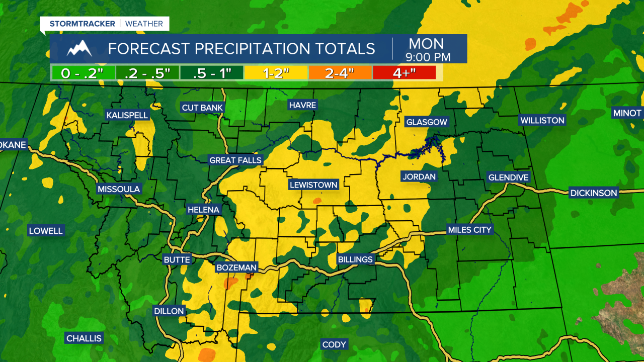
We will also receive a good amount of moisture Saturday through Monday as a lot of locations will receive at least .25” of precipitation, and some areas, especially east of I-15, may receive over 1” of precipitation.
The temperatures will cool down a lot from Saturday through Monday as highs on Saturday are going to range from the mid 50s along the Rocky Mountain Front to the upper 70s in northeastern Montana and highs on Sunday and Monday are going to be in the 30s and low to mid 40s. Make sure you bundle up if you are going to be outdoors Sunday and/or Monday!
It is also going to be breezy on Saturday along the Rocky Mountain Front as sustained wind speeds are going to be between 10 and 25 mph, and gusts over 40 mph are possible. Widespread breezy conditions are then expected Saturday night into Sunday as sustained wind speeds are going to be between 10 and 25 mph, and this will be a cold wind as it will be coming out of the northwest. There is then going to be a little breeze around on Monday as sustained wind speeds are going to be between 5 and 20 mph.
Temperatures will gradually warm back up as we go through next week as highs are going to be in the 40s and mid to upper 30s on Tuesday; the mid to upper 40s and low to mid 50s on Wednesday; and the upper 40s and low to mid 50s on Thursday.
On Tuesday and Wednesday, we are going to have mostly cloudy skies and there are going to be some scattered rain and snow showers around as we remain in an unsettled weather pattern. Some more scattered rain and snow showers are then possible on Thursday, and it will be partly cloudy.