A LAKE WIND ADVISORY is in effect for Fort Peck Lake until 9pm Thursday.

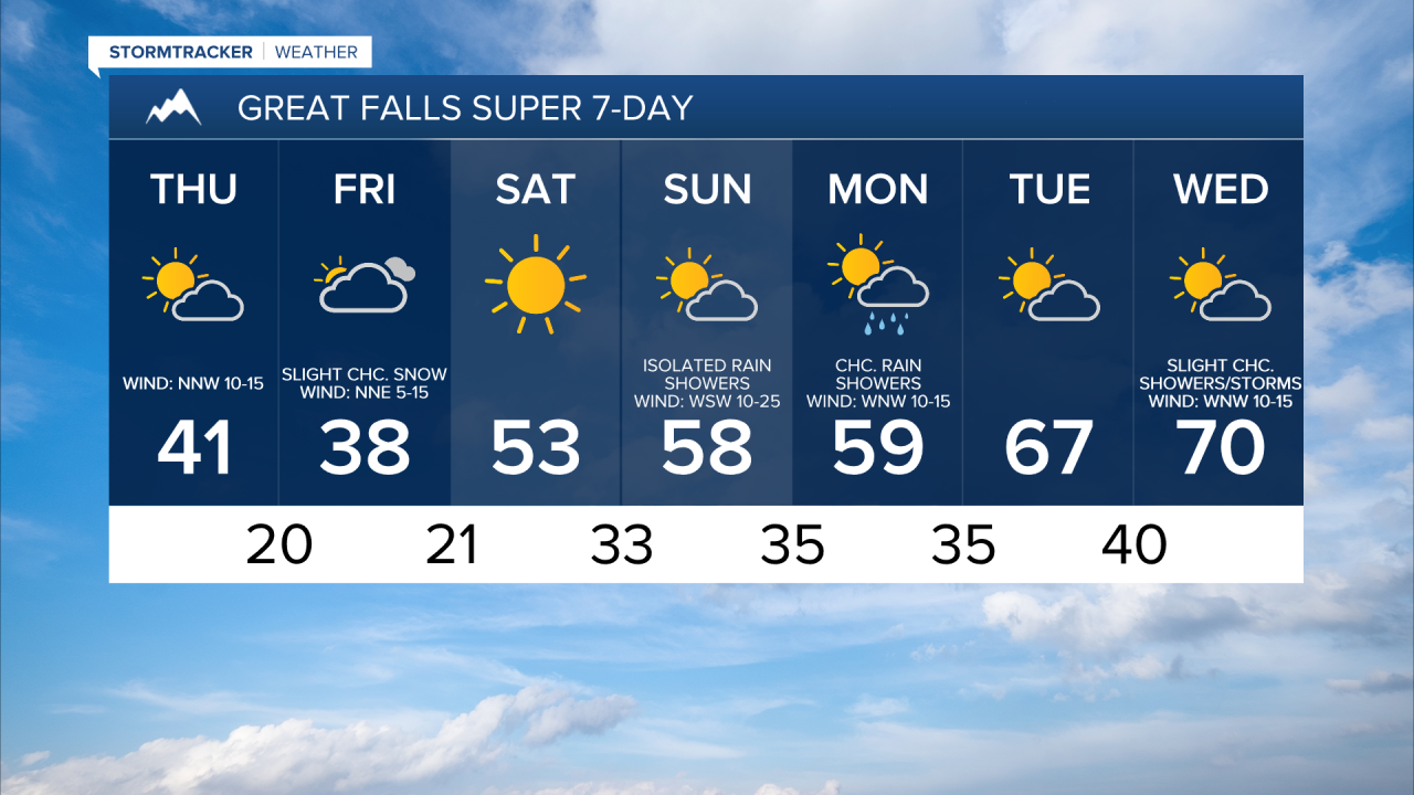
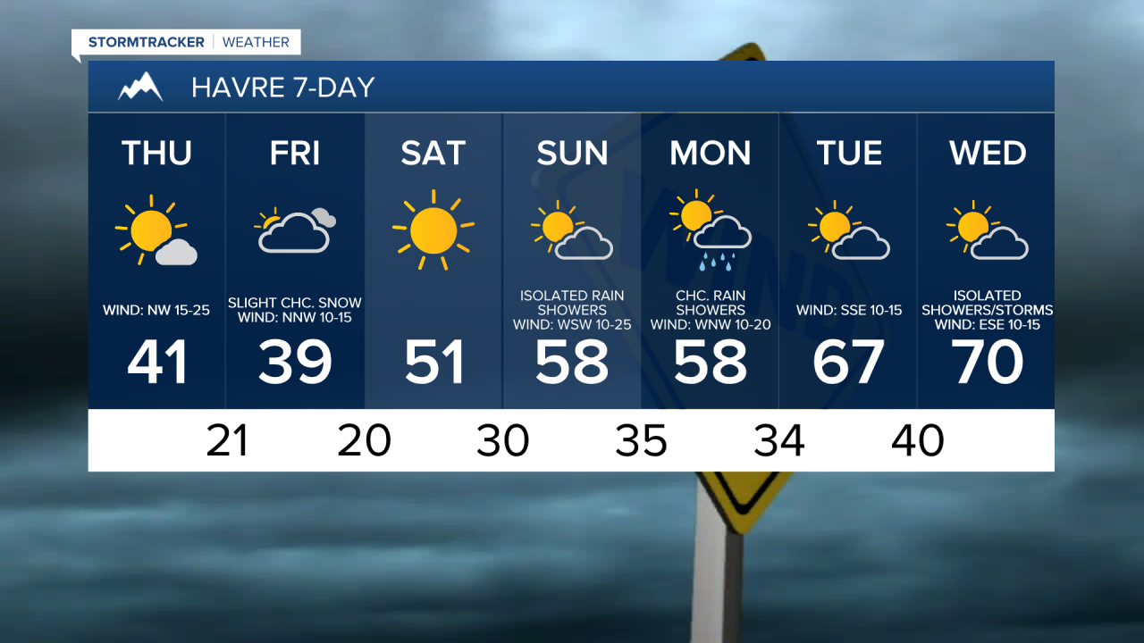
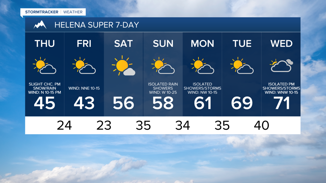
Scattered snow showers will gradually taper off as we go through this evening and the first half of tonight, with mainly dry conditions expected during the second half of tonight. Little to no new snow accumulation is expected. We are also going to have decreasing clouds and decreasing wind tonight, although it will remain breezy for the entire night tonight in eastern portions of north-central Montana as sustained wind speeds are going to be between 10 and 25 mph. It is also going to be cold tonight as lows are going to be in the 20s and upper teens.
For tomorrow, we are going to have partly to mostly sunny skies with a few snow/rain showers along the Divide, around the Helena area, and in northeastern Montana. Mostly dry conditions are expected elsewhere. It is also going to be cold again tomorrow as highs are only going to be in the upper 30s and low to mid 40s in most locations. We are also going to have gusty winds around again tomorrow as sustained wind speeds are going to be between 10 and 30 mph, with the wind getting stronger the further east of I-15 you go.
On Friday, we are going to have partly to mostly cloudy skies with a few isolated snow showers around. It is also going to be cold on Friday as highs are going to be in the mid to upper 30s and low to mid 40s. There is also going to be a breeze around in some areas on Friday as sustained wind speeds are going to be between 10 and 25 mph, and the strongest wind is going to be in northeastern Montana.
We are then going to have really nice weather on Saturday as we are going to have lots of sunshine, mainly dry conditions, little wind (sustained wind speeds between 5 and 15 mph), and warmer temperatures as highs are going to be in the mid to upper 40s and low to mid 50s in most locations.
There are then going to be a few scattered rain and mountain snow/rain showers around on Sunday and Monday as a couple disturbances pass through our area. We are also going to have partly cloudy skies and pleasant temperatures on these two days as highs are going to be in the 50s and low to mid 60s. It is also going to be breezy on Sunday as sustained wind speeds are going to be between 10 and 25 mph, and it is going to be a little breezy on Monday as sustained wind speeds are going to be between 5 and 20 mph.
On Tuesday, we are going to have partly cloudy skies, dry conditions, and warmer temperatures as highs are going to be in the 60s. We are then going to have partly to mostly cloudy skies on Wednesday with a few isolated showers and thunderstorms around as another disturbance begins to impact our area. It is also going to be warm and a little breezy on Wednesday as highs are going to be in the upper 60s and low to mid 70s, and sustained wind speeds are going to be between 5 and 20 mph.