We are going to have partly to mostly cloudy skies tonight in locations around and west of I-15, and we are going to have partly cloudy to mostly clear skies tonight in locations east of I-15. There are also going to be some isolated rain and mountain rain/snow showers around tonight, mainly in/around the Helena area. It is also going to be cool tonight as lows are going to be in the mid to upper 30s and low to mid 40s in most locations.
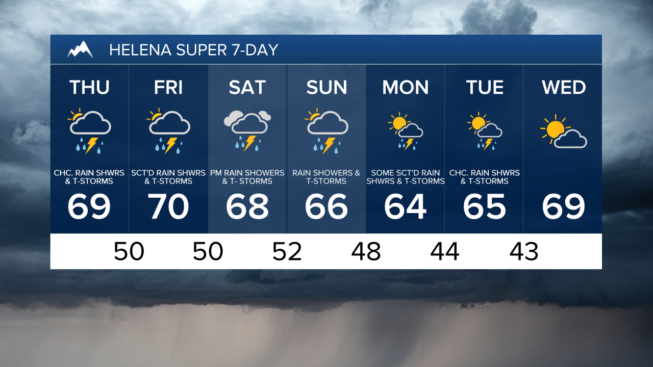
For tomorrow, we are going to have partly to mostly cloudy skies with a few scattered rain showers and thunderstorms around, generally during the afternoon/evening and generally in/around the Helena area. There is also going to be a little bit of a breeze around tomorrow as sustained wind speeds are going to be between 5 and 20 mph. We are also going to have seasonable temperatures tomorrow as highs are going to be in the mid to upper 60s and low to mid 70s.
There are then going to be some isolated rain showers and thunderstorms around tomorrow night in north-central Montana, and there are going to be some scattered rain showers and thunderstorms around tomorrow night in south-central Montana. On Friday, there are going to be a few scattered rain showers and thunderstorms around in north-central Montana, and there are going to be scattered rain showers and thunderstorms around, especially during the afternoon/evening, in south-central Montana as a disturbance works its way through our area. We are also going to have mostly cloudy skies tomorrow night and Friday.
It is also going to be cool/mild tomorrow night as lows are going to be in the mid to upper 40s and low 50s. Seasonable temperatures are then expected on Friday as highs are going to be in the mid to upper 60s and low to mid 70s. There is also going to be a little bit of a breeze around on Friday as sustained wind speeds are going to be between 5 and 20 mph.
On Saturday, there are going to be scattered rain showers and thunderstorms around, generally during the afternoon and evening, as another disturbance begins to work its way through our area. Widespread rain showers and thunderstorms are then likely on Sunday as this disturbance leaves our area and as another disturbance begins to pass through our area. There are then going to be scattered rain showers and thunderstorms around on Monday, especially in locations east of I-15, as this disturbance leaves our area. We are also going to have mostly cloudy to cloudy skies from Saturday through Monday.
We are going to have seasonable temperatures again on Saturday as highs are going to be in the mid to upper 60s and low to mid 70s. We are then going to have below average temperatures on Sunday and Monday as highs are only going to be in the 60s. There is also going to be a little bit of a breeze around on Monday as sustained wind speeds are going to be between 5 and 20 mph.
On Tuesday, we are going to have partly cloudy skies with some scattered rain showers and thunderstorms around, especially during the afternoon and evening. We are then going to have increasing clouds and mostly dry conditions on Wednesday. It is also going to be cool again on Tuesday as highs are only going to be in the low to mid 60s, but it will be warmer on Wednesday as highs are going to be in the upper 60s and low 70s. There is also going to be a little bit of a breeze around on Tuesday as sustained wind speeds are going to be between 5 and 20 mph.