A LAKE WIND ADVISORY is in effect for Fort Peck Lake from 4am until 8pm Tuesday. Sustained wind speeds are going to be between 20 and 25 mph, and wind gusts up to 35 mph are going to be possible at times.

A cold front is going to pass through north-central and central Montana (from north to south) between midnight and 9am on Tuesday. Ahead of this front, we have been dealing with gusty winds, and we are going to continue to have gusty winds around tonight as sustained wind speeds are going to be between 10 and 25 mph, and wind gusts up to 40 mph are going to be possible at times. Also, there is going to be a short period of strong winds (gusts up to 50 mph possible) when the cold front passes through. The wind is also going to shift direction tonight as the wind is going to be coming out of the WSW ahead of the front and out of the NW behind the front.
For tomorrow, we are going to continue to have gusty winds around throughout the day in eastern Montana and along the Rocky Mountain Front as sustained wind speeds are going to be between 10 and 30 mph, and wind gusts over 40 mph are going to be possible at times. In central/north-central Montana, there will be a break from the wind in the morning, but it will turn a bit breezy during the afternoon and evening with gusts over 30 mph possible at times. The wind is also going to be coming out of the west tomorrow.
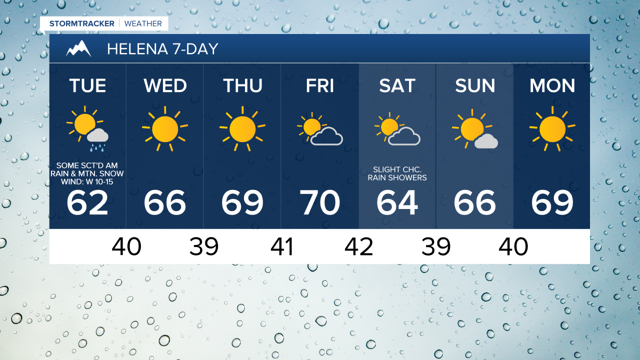
There are also going to be scattered rain and mountain snow showers around along and behind the cold front. Above 6000 feet, rain will transition over to all snow, and light snow accumulations of a couple inches are possible. Between 5000 and 6000 feet, rain will likely transition over to a rain/snow mix, with a short period of just snow possible. However, little to no snow accumulation is expected. Below 5000 feet, mainly rain is expected, but if the precipitation gets heavy enough, some wet snowflakes may mix in. Also, this precipitation will move from the northwest towards the southeast and will generally occur between midnight and 10am on Tuesday.
We are also going to have falling temperatures behind the front tonight as lows tomorrow morning are going to be in the mid to upper 30s and low to mid 40s in most locations. It is then going to be cooler tomorrow than it was today as highs are going to be in the mid to upper 50s and low to mid 60s. We are also going to have partly cloudy skies tonight and decreasing clouds tomorrow, with mostly sunny skies expected tomorrow afternoon/evening.
On Wednesday, we are going to have mostly sunny skies with a couple stray showers around in northeastern Montana as a disturbance passes by our area. It is also going to be windy in eastern Montana on Wednesday as wind gusts up to 50 mph are going to be possible at times, and it is going to be breezy in eastern portions of north-central Montana on Wednesday as wind gusts over 30 mph are going to be possible at times. In the rest of north-central Montana, there is just going to be a little breeze around on Wednesday. Also, highs are going to be in the mid to upper 50s and low to mid 60s on Wednesday.
Lots of sunshine and dry conditions are then expected on Thursday, and partly cloudy to mostly sunny skies and dry conditions are expected on Friday as an upper-level ridge is going to be in control of our weather. It is also going to be mild on these two days as highs are going to be in the mid to upper 60s and low to mid 70s.
A weak cold front is then going to pass through our area on Saturday, providing us with cooler temperatures (highs in the upper 50s and low to mid 60s), and a few isolated rain showers, generally in locations east of I-15. We are also going to have partly cloudy skies on Saturday.
Mostly to mainly sunny skies and dry conditions are then expected on Sunday and Monday as an upper-level ridge is once again going to be in control of our weather. The temperatures are also going to warm back up some over these two days as highs are going to be in the 60s on Sunday and the mid to upper 60s and low 70s on Monday.