A WINTER WEATHER ADVISORY is in effect for the Big Belt, Bridger, and Castle Mountains; the Gallatin Valley; the Gallatin and Madison County Mountains; and the Centennial Mountains until 11pm Monday. Up to one inch of new snow accumulation is possible.
A WINTER WEATHER ADVISORY is in effect for portions of southern Montana until 5am Tuesday. Up to 4 inches of new snow accumulation is possible.
A WINTER WEATHER ADVISORY is in effect for portions of northeastern Montana until 5am Thursday. Up to 6 inches of snow accumulation is possible.
A WINTER STORM WARNING is in effect for portions of eastern Montana until 5am Thursday. 6 to 18 inches of snow accumulation and gusty winds are expected.
A BLIZZARD WARNING is in effect for southeastern Montana until 5am Thursday. Blizzard conditions are expected. 10 to 16 inches of snow accumulation is expected.

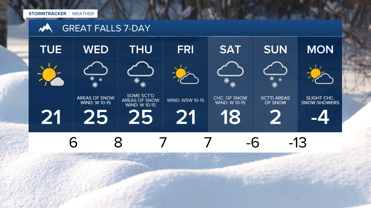
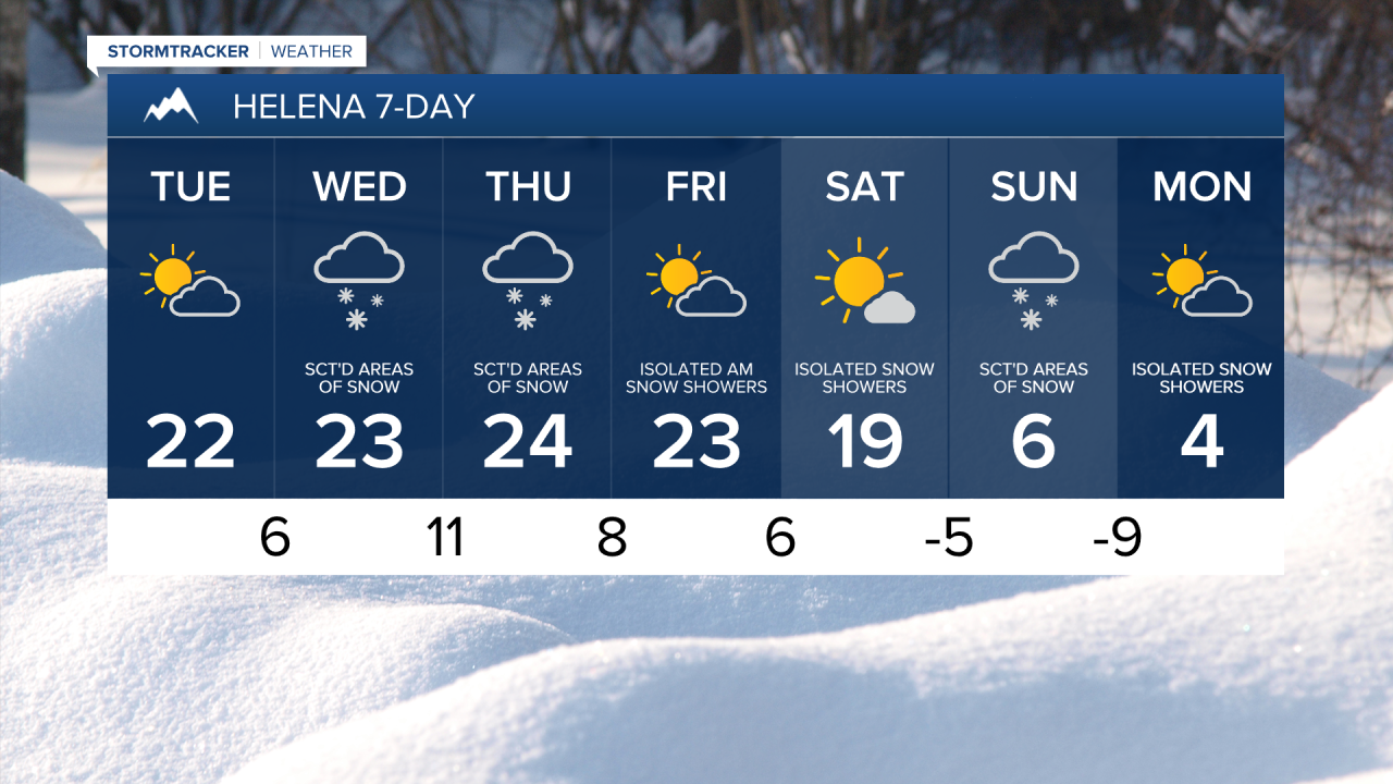
We are going to have mostly cloudy skies tonight with some isolated areas of snow around, generally before midnight and mainly in central Montana. New snow accumulation of up to an inch is possible. It is also going to be cold tonight as lows are going to be in the single digits above/below zero.
For tomorrow, we are going to have decreasing clouds, dry conditions, and cold temperatures as highs are going to be in the teens and low to mid 20s in most locations.
On Wednesday, there are going to be areas of light to moderate snow around as an Alberta clipper passes through our area. This is a fast-moving disturbance, so it is only going to snow for part of the day, and snow accumulations will be on the lighter side (coating to 3 inches). It is also going to be cold on Wednesday as highs are going to be in the mid to upper teens and low to mid 20s. There is also going to be a breeze around on Wednesday as sustained wind speeds are going to be between 10 and 20 mph, and this wind will make it feel even colder.

There are then going to be some scattered areas of snow around on Thursday as another disturbance passes through our area. Once again, only light snow accumulations are expected with most locations receiving less than 3 inches of snow. We are then going to have partly cloudy skies on Friday with a few isolated snow showers around during the morning as this disturbance leaves our area. It is also going to continue to be cold on these two days as highs are going to be in the mid to upper teens and low to mid 20s. There is also going to be a little bit of a breeze around on these two days as sustained wind speeds are going to be between 5 and 20 mph.
On Saturday, we are going to have partly cloudy skies with a few scattered areas of snow around, generally during the afternoon and evening, as a cold front approaches our area. We are then going to have mostly cloudy skies on Sunday with scattered areas of snow around as this cold front leaves our area. The temperatures are also going to cool down a lot over these two days as highs are going to be in the mid to upper teens and low 20s on Saturday and the single digits above/below zero on Sunday. Also, lows Saturday night are going to be in the single digits below zero in many locations.
Monday is going to be a frigid day as highs are going to be in the single digits above/below zero in most locations, and lows Sunday night into Monday morning and Monday night into Tuesday morning are going to be in the single digits and teens below zero in most locations. This arctic air is likely going to stick around through at least the middle of next week, so prepare now for an extended period of bitter cold temperatures. We are also going to have partly to mostly cloudy skies on Monday with some isolated snow showers around, generally during the morning.