


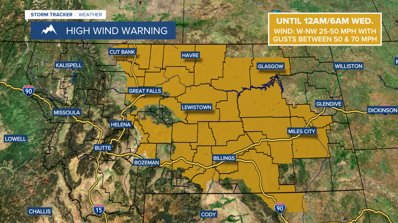
A HIGH WIND WARNING is in effect for a lot of Montana east of the Divide until 12am/6am Wednesday.
A BLIZZARD WARNING is in effect for the Highwood and Little Belt mountains until 12am Thursday.

A WINTER STORM WARNING is in effect for the Rocky Mountain Front until 12am Thursday.
A WINTER STORM WARNING is in effect for several of the mountain ranges in central, southwestern, and south-central Montana until 12am/12pm Thursday.

A WINTER WEATHER ADVISORY is in effect for the Bears Paw mountains, southern Blaine County, Liberty County, and eastern Toole County until 6am Wednesday.
A WINTER WEATHER ADVISORY is in effect for the lower elevations in Cascade, Fergus, and Judith Basin counties until 12pm Wednesday.
A WINTER WEATHER ADVISORY is in effect for the Boulder and Elkhorn mountains as well as MacDonald Pass until 12am Thursday.

A WINTER WEATHER ADVISORY is in effect for the West Glacier area, the Butte and Blackfoot region as well as the Bitterroot and Sapphire mountains until 11am Wednesday.

A FLOOD ADVISORY is in effect for all of Blaine County and portions of Chouteau, Fergus, and Hill counties until 12pm Thursday.
A FLOOD WATCH is in effect for southwestern Phillips County until 9pm Tuesday and for Clear Creek at Chinook from 12am until 9pm Wednesday.

A strong spring storm is going to continue to impact Montana through Wednesday with a lot of wind, below average temperatures, and widespread precipitation.
It is going to continue to be very windy this evening and tonight as sustained wind speeds are going to be between 20 and 40 mph, and wind gusts between 50 and 70 mph are expected. The wind will start to diminish some later on tonight though. For tomorrow, the wind is not going to be as strong as it was today, but we are still going to have gusty winds around for a good chunk of the day as sustained wind speeds are going to be between 10 and 30 mph, and wind gusts up to 50 mph are possible. Little to no wind is then expected tomorrow night and Thursday.
Widespread precipitation is also likely this evening and tonight, although the precipitation will taper off a bit from east to west as we go through the night. In the lower elevations in central Montana and in western portions of north-central Montana, rain will mix in with and switch over to snow as we go through this evening and tonight. In the lower elevations in eastern portions of north-central Montana (with the exception of Fergus County), precipitation will mainly be in the form of rain tonight. Tomorrow, there is going to be widespread precipitation around during the morning, with the precipitation becoming more showery during the afternoon and evening. In the lower elevations in central Montana and in western portions of north-central Montana, precipitation will switch from snow to rain as we go through the morning as the snow levels rise back up. Also, in the mountains, all snow is expected tonight and tomorrow.
There are then going to be scattered lower elevation rain and mountain snow showers around tomorrow night. A few lingering rain and mountain snow showers are then expected on Thursday as this storm system finally departs our area. We are also going to have overcast skies tonight and tomorrow, mostly cloudy to overcast skies tomorrow night, and decreasing clouds on Thursday.
Significant snow accumulation is expected at and above mountain pass level through Thursday morning as 6-36” of snow is expected, with the highest snow amounts in the Little Belt mountains. This snow, along with the wind, will create difficult travel conditions in the mountains and over many of the mountain passes through tomorrow, so please use extreme caution when traveling and try and delay your travel if you can. Over Kings Hill Pass, travel may be impossible at times due to blizzard conditions, so definitely avoid traveling in that area if you can.
In the lower elevations, up to 6” of snow accumulation is possible, but most locations will receive less than 2” of snow accumulation through tomorrow night. In the lower elevations, the highest snow amounts will be in locations that are near the mountains, including around Lewistown and between Belt and Geyser. Difficult travel conditions are also expected along portions of US-87 in Cascade, Fergus, and Judith Basin counties tonight and tomorrow morning due to the snow and wind.

A lot of additional precipitation (rain and melted snow) is also expected through Thursday morning as most of central and north-central Montana will receive between .5” and 2.5” of new precipitation. This precipitation may also lead to some minor flooding, especially around the Bears Paw mountains and in Blaine/Hill counties.

We are also going to have a wide range of temperatures tomorrow as highs are going to range from the mid 30s to the low 60s, with the coldest temperatures in central Montana and western portions of north-central Montana, and the warmest temperatures along central and eastern portions of the Hi-Line. It is then going to be warmer for everyone on Thursday as highs are going to be in the 50s and 60s.
Beautiful weather is then expected Friday and this weekend as an upper-level ridge is going to be in control of our weather. On these three days, we are going to have lots of sunshine and mostly dry conditions (just a slight chance of showers and thunderstorms on Sunday). The temperatures are also going to warm up a lot over these three days as highs are going to be in the 60s and low 70s on Friday, and the 70s and low 80s this weekend. The wind is also not going to be too bad on these three days, but it will be a bit breezy this weekend as sustained wind speeds are going to be between 10 and 20 mph.
Some isolated rain showers and thunderstorms are then possible on Monday and Tuesday as a couple weak disturbances pass through our area. We are also going to have partly to mostly sunny skies and breezy conditions on these two days as sustained wind speeds are going to be between 10 and 25 mph. The temperatures are also going to cool down some over these two days as highs are going to be in the 70s and low 80s on Monday and the mid to upper 60s and low to mid 70s on Tuesday.


