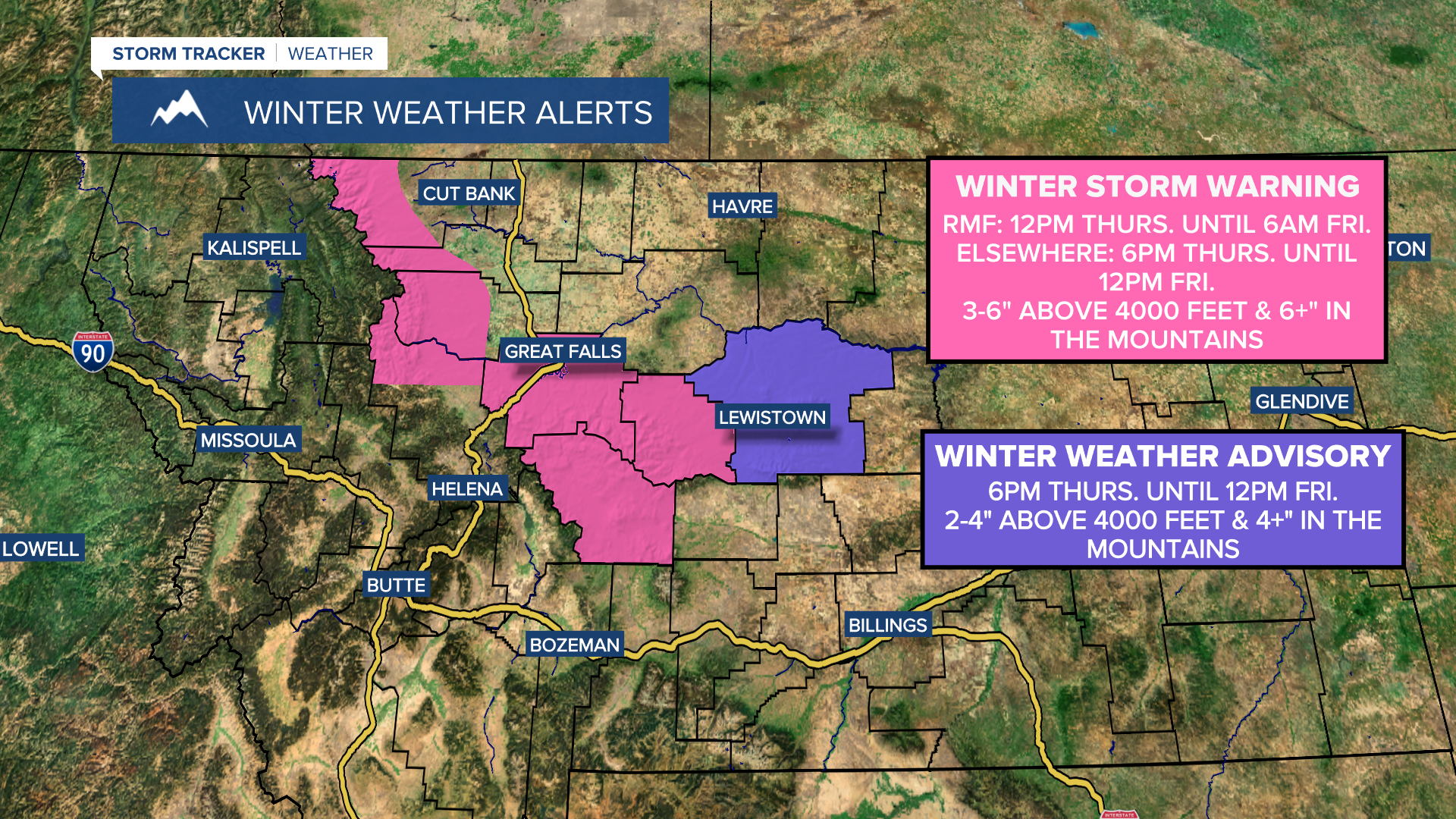


A WINTER STORM WARNING is in effect for the Rocky Mountain Front until 6am Friday, and for locations above 4000 feet in Cascade County, Judith Basin County, and Meagher County until 12pm Friday. 3 to 6 inches of snow accumulation is expected above 4000 feet, while 6+ inches of snow accumulation is expected at and above pass level.
A WINTER WEATHER ADVISORY is in effect for Fergus County until 12pm Friday. 2 to 5 inches of snow accumulation is expected above 4000 feet, while 5+ inches of snow accumulation is expected in the mountains.
A WINTER WEATHER ADVISORY is also in effect for southwestern Phillips County from 9pm Thursday until 9am Friday. Up to 2 inches of snow accumulation is possible above 3500 feet.

A LAKE WIND ADVISORY is in effect for Fort Peck Lake until 9pm Friday. Sustained wind speeds are going to be between 20 and 30 mph, and wind gusts up to 55 mph are going to be possible at times.

There are going to be areas of rain and snow around tonight as a storm system slowly works its way through our area. Snow levels will also get as low as about 3500 feet tonight, so several locations will at least see some snow flying. There are then going to be scattered rain and snow showers around tomorrow, especially during the morning, as this storm system begins to leave our area. Snow levels will also start off around 3500 to 4000 feet at daybreak tomorrow, but will rise as the day goes on. We are also going to have mostly to partly cloudy skies tomorrow.
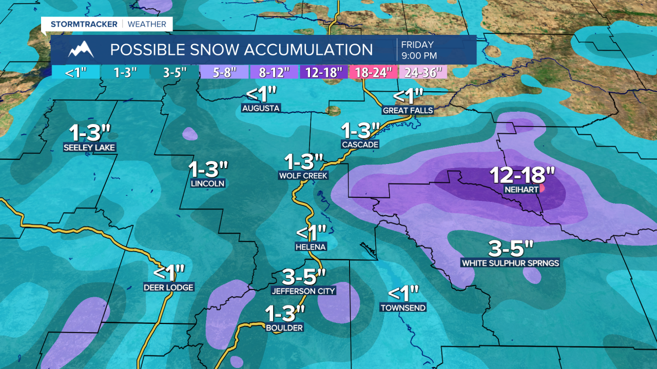
In the mountains, 6 to 18 inches of total snow accumulation is expected by Friday evening. In the lower elevations, 0 to 6 inches of total snow accumulation is expected by Friday evening, with the highest amounts occurring in the northerly upslope regions of the mountain ranges in central Montana.

We are also going to have diminishing wind Thursday evening and Thursday night, with windy conditions (sustained wind speeds between 15 and 35 mph) expected before midnight and breezy conditions (sustained wind speeds between 10 and 25 mph) expected after midnight. It is then going to be breezy on Friday as sustained wind speeds are going to be between 10 and 25 mph, and wind gusts up to 40 mph are going to be possible at times. It is also going to be chilly tonight and tomorrow as lows tonight are going to be in the upper 20s and low to mid 30s, and highs tomorrow are going to be in the 40s and low 50s.
On Saturday, we are going to have partly to mostly cloudy skies with some scattered rain and snow showers around, generally in eastern Montana, as we continue to remain in an unsettled weather pattern. We are then going to have partly cloudy to mostly sunny skies on Sunday with a few scattered rain and snow showers around, generally in south-central Montana, as a disturbance passes by our area to the south. The temperatures are also going to warm up a little this weekend as highs on Saturday are going to be in the upper 40s and low to mid 50s, and highs on Sunday are going to be in the mid to upper 50s and low 60s.
Partly cloudy to mostly sunny skies and dry conditions are then expected on Monday. It is also going to be warmer on Monday than it is going to be this weekend as highs are going to be in the 60s.
On Tuesday, there are going to be some isolated rain showers and thunderstorms around, generally during the afternoon and evening, as a disturbance passes through our area. We are then going to have partly cloudy skies and mostly dry conditions on Wednesday and Thursday.
It is also going to be breezy on Tuesday and Wednesday as sustained wind speeds are going to be between 10 and 20 mph. The temperatures are also going to warm up a lot between Tuesday and Thursday as highs on Tuesday are going to be in the mid to upper 60s; highs on Wednesday are going to be in the low to mid 70s; and highs on Thursday are going to be in the mid to upper 70s and low 80s.


