A RED FLAG WARNING is in effect for all of Montana from 12pm Wednesday until 12am Thursday. Gusty to strong winds, low relative humidity, and very hot temperatures are going to make it hard to contain new and existing fires. Isolated dry thunderstorms during the afternoon and evening may also spark some new fires.
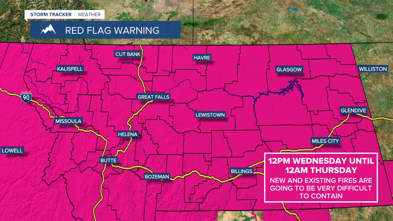
A HEAT ADVISORY is in effect for central and eastern portions of Montana from 12pm until 8pm Wednesday. High temperatures are going to be between 95˚ and 105˚.

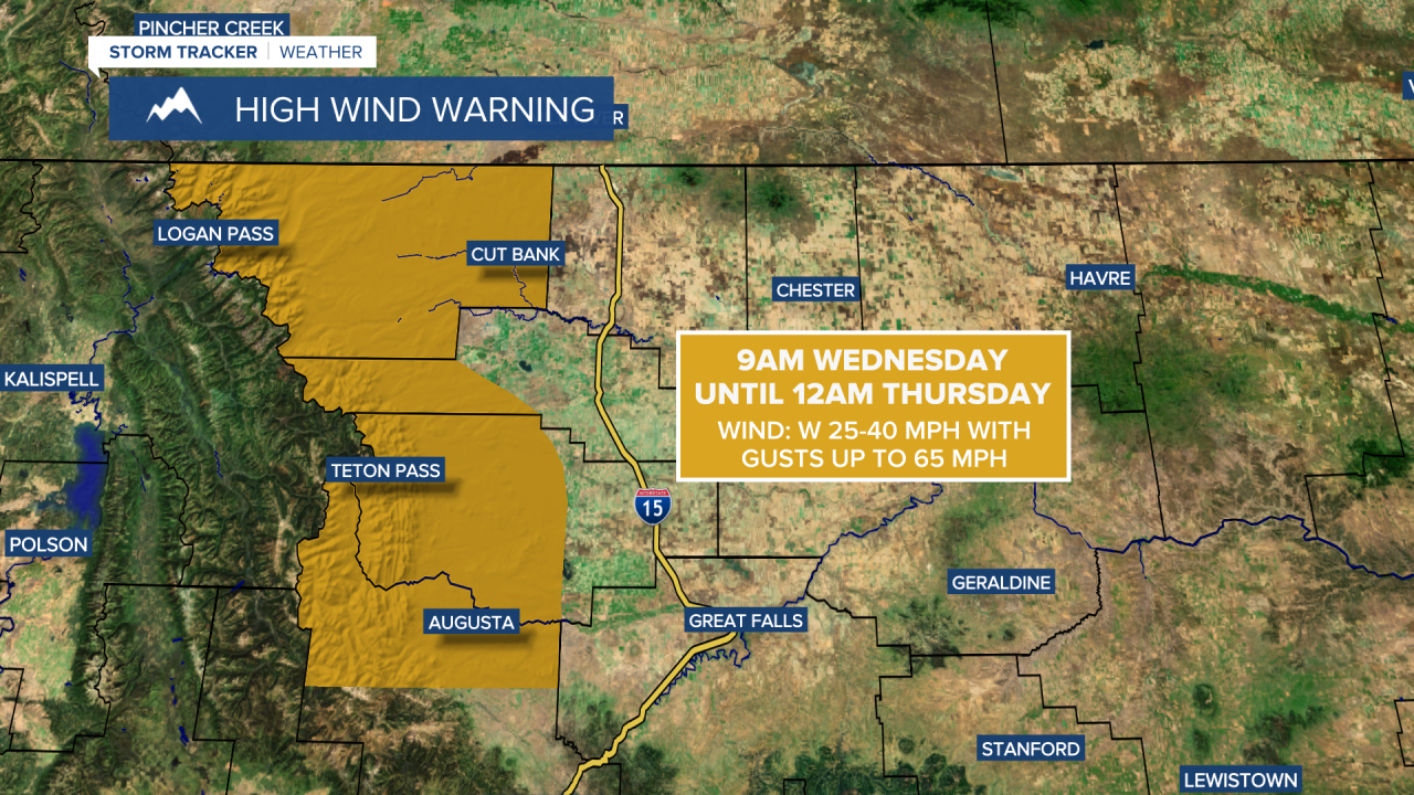
A HIGH WIND WARNING is in effect for the Rocky Mountain Front and all of Glacier County from 9am Wednesday until 12am Thursday. Sustained wind speeds are going to be between 25 and 40 mph, and wind gusts up to 65 mph are going to be possible at times.
The haze and smoke is going to continue to be an issue tonight and tomorrow, and tomorrow will definitely be a lot smokier than today was. The air quality will likely be unhealthy for sensitive groups at times tonight and tomorrow, and in some locations, the air quality may become unhealthy for everyone. As we head into tomorrow night and Thursday, a cold front will bring much cleaner air into north-central and central Montana, so we will finally get a break from the haze and smoke.
Outside of the haze/smoke, we are going to have mostly to mainly clear skies tonight and increasing clouds tomorrow. Some isolated showers and thunderstorms are also possible tomorrow afternoon and evening.
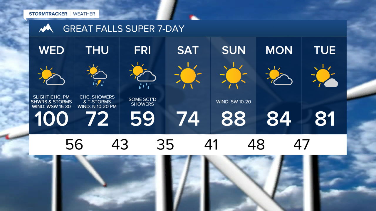
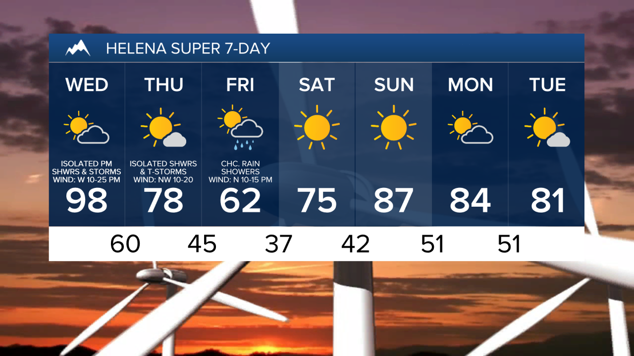
Lows tonight are going to be in the 50s and low 60s. Record high temperatures are then expected in many locations tomorrow as highs are going to be in the 90s and low 100s, with the hottest temperatures expected along the eastern half of the Hi-Line. We are also going to have strong winds around tomorrow along the Rocky Mountain Front as sustained wind speeds are going to be between 20 and 40 mph, and wind gusts up to 65 mph are going to be possible at times. East of the Rocky Mountain Front, we are going to have gusty winds around tomorrow as sustained wind speeds are going to be between 10 and 30 mph, and wind gusts up to 50 mph are going to be possible at times. In most locations, this wind is going to be coming out of the west or west-southwest.
Extremely high fire danger is also expected tomorrow due to the combination of gusty to strong winds, very hot temperatures, and low relative humidity, so PLEASE do your part to not start any new fires. This is going to be one of the highest fire danger days that we had had all summer.
For tomorrow night, we are going to have partly cloudy skies with a chance of rain showers and thunderstorms, especially in locations east of I-15. The wind is also going to gradually diminish as the night goes on. Also, lows tomorrow night are going to be in the 50s and low 60s.
On Thursday, we are going to have partly cloudy to mostly sunny skies with a chance of showers and thunderstorms. We are then going to have partly cloudy skies with some scattered showers around on Friday. Some mountain snow is also possible on these two days, and light snow accumulations are possible in the higher elevations Thursday night into Friday.
The temperatures are also going to cool down A LOT over these two days as highs on Thursday are going to be in the 60s and 70s, and highs on Friday are going to be in the 50s and low to mid 60s. Friday is also going to be the coolest day that we have had in months. It is also going to be breezy on Thursday as sustained wind speeds are going to be between 10 and 25 mph, and wind gusts up to 40 mph are going to be possible at times. There is then going to be a little breeze around on Friday as sustained wind speeds are going to be between 5 and 20 mph. Also, the wind on these two days is going to be coming out of the north, which will help keep the smoke out of our area.
It is going to be COLD Saturday morning as lows are going to be in the 30s in most locations. There are also going to be areas of frost around Saturday morning, so please make sure you take the necessary precautions to protect any sensitive plants that you may have. As we go through this weekend, the temperatures are going to warm up a lot as highs are going to be in the 70s on Saturday and the 80s on Sunday. We are also going to have lots of sunshine and mainly dry conditions this weekend.
On Monday and Tuesday, we are going to have partly cloudy to mostly sunny skies and mostly dry conditions. It is also going to be warm on these two days as highs are going to be in the upper 70s and low to mid 80s.