A LAKE WIND ADVISORY is in effect for Fort Peck Lake until 9pm Friday. Sustained wind speeds are going to be between 10 and 20 mph, and wind gusts up to 30 mph are going to be possible at times.

Record or near record low temperatures are expected tonight and tomorrow night as lows are going to be in the mid to upper 20s and low to mid 30s in most locations. There is also going to be widespread frost around tonight and tomorrow night, and several locations are going to have a hard freeze tonight and/or tomorrow night, so make sure you take the necessary precautions to protect any sensitive plants that you may have.


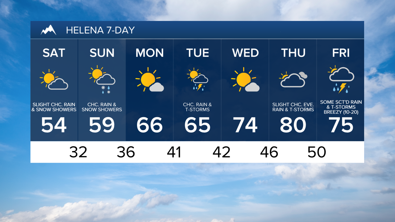
Scattered mixed rain and snow showers will continue to taper off this evening. There are then going to be some isolated rain and snow showers around tonight. We are also going to have partly cloudy skies tonight, and there are going to be some patchy areas of fog around tonight as well, especially in locations that have some snow on the ground.
For tomorrow, we are going to have partly to mostly cloudy skies with some isolated rain and snow showers around in central Montana and scattered rain and snow showers around in eastern Montana. It is also going to be cool/chilly tomorrow as highs are going to be in the mid to upper 40s and low to mid 50s in most locations. There is also not going to be much wind around tomorrow as sustained wind speeds are going to be between 5 and 15 mph in most locations.
On Sunday, we are going to have partly cloudy to mostly sunny skies with a few scattered rain and snow showers around, generally in south-central Montana, as a disturbance passes by our area to the south. It is also going to be warmer on Sunday than it is going to be tomorrow as highs are going to be in the mid to upper 50s and low to mid 60s.
We are then going to have increasing clouds and mainly dry conditions on Monday as a disturbance begins to approach our area. There are then going to be a few scattered rain showers and thunderstorms around on Tuesday, generally during the afternoon and evening, as this disturbance passes through our area. We are also going to have seasonable temperatures on these two days as highs are going to be in the 60s. There is also going to be a little bit of a breeze around on these two days, especially during the PM hours, as sustained wind speeds are going to be between 5 and 20 mph.
Partly cloudy to mostly sunny skies and dry conditions are then expected on Wednesday as high pressure is going to be in control of our weather. We are then going to have partly to mostly cloudy skies with a slight chance of evening rain showers and thunderstorms on Thursday as a disturbance begins to approach our area. The temperatures are also going to warm up some over these two days as highs are going to be in the low to mid 70s on Wednesday and the upper 70s and low 80s on Thursday. It is also going to be breezy on Wednesday as sustained wind speeds are going to be between 10 and 20 mph.
There are then going to be some scattered rain showers and thunderstorms around on Friday, especially during the afternoon and evening, as a disturbance passes through our area. It is also going to be warm and breezy on Friday as highs are going to be in the 70s and sustained wind speeds are going to be between 10 and 20 mph.