An AIR QUALITY ALERT is in effect for all of Montana until at least 9am Friday. The air quality is going to be unhealthy for everyone at times.

Smoky/hazy skies and poor air quality will likely continue to be an issue through the weekend. On Friday, the flow aloft will start to come out of the west/northwest, which should bring some cleaner air into our area. A disturbance is then going to clip our area Friday night/Saturday, and that will switch the air flow aloft back to a northerly/northwesterly direction, which will likely bring some more smoke back into our area. However, as we head into Sunday and early next week, the air flow will switch to come out of the west and southwest, which should get rid of most of the smoke.
Over the next few days, the air quality at times is going to be unhealthy for at least sensitive groups if not unhealthy for everyone. This means that you should try and limit your time outdoors over the next few days, especially if you are sensitive to increased particulate matter in the atmosphere. The air quality should then improve a lot as we head into the later part of Sunday and next week.
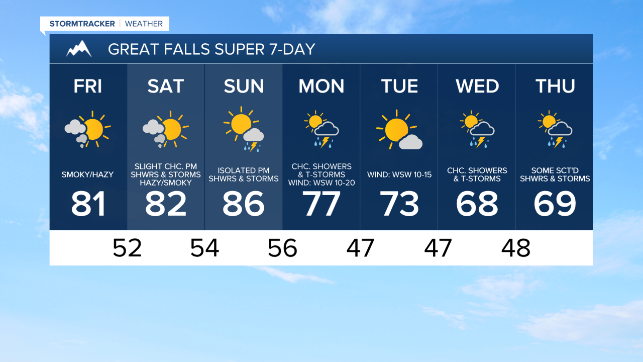
Outside of the haze/smoke, mainly clear skies are expected tonight and mainly sunny skies are expected tomorrow. It is also going to be cool tonight as lows are going to be in the 40s and mid to upper 30s. It is then going to be warmer tomorrow than it was today as highs are going to be in the mid to upper 70s and low to mid 80s. Some isolated showers and storms are also possible from late tomorrow afternoon through tomorrow night, especially along the Hi-Line, as a disturbance passes by our area to the north. There is also going to be a little breeze around tomorrow in some areas as sustained wind speeds are going to be between 5 and 20 mph.
On Saturday and Sunday, we are going to have mostly to mainly sunny skies with some isolated showers and thunderstorms around during the PM hours. It is also going to be warm this weekend as highs are going to be in the upper 70s and low to mid 80s on Saturday and the 80s and low 90s on Sunday. There is also going to be a little breeze around in some areas this weekend.
There are then going to be some scattered showers and thunderstorms around on Monday as a cold front passes through our area. It is also going to be breezy and a little cooler on Monday as sustained wind speeds are going to be between 10 and 25 mph, and highs are going to be in the 70s and low to mid 80s. This cold front should also get rid of most of the smoke.
On Tuesday, we are going to have mostly sunny skies and mostly dry conditions. We are then going to have a chance to see some more scattered showers and thunderstorms on Wednesday and Thursday as a couple more disturbances pass through our area. The temperatures are also going to cool down some over these three days as highs ae going to be in the 70s on Tuesday and the mid to upper 60s and low to mid 70s on Wednesday and Thursday. It is also going to be a bit breezy on Tuesday as sustained wind speeds are going to be between 10 and 20 mph.