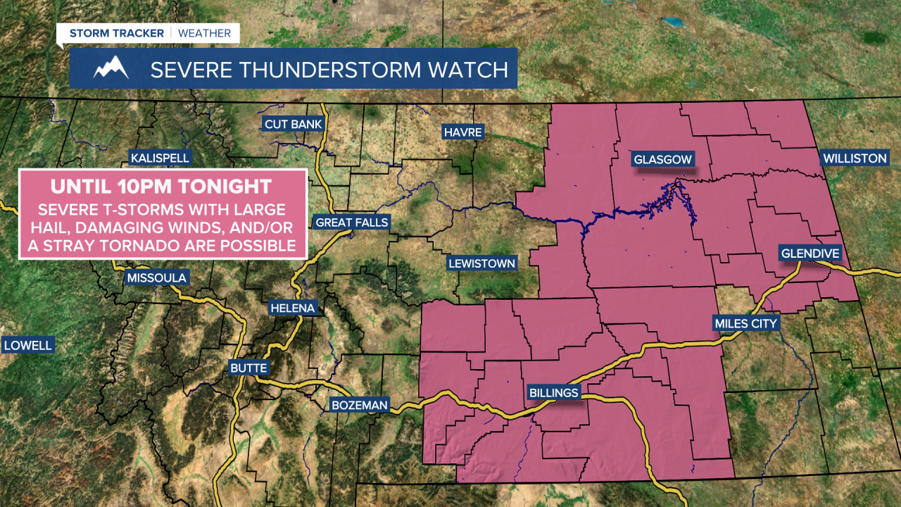
A SEVERE THUNDERSTORM WATCH is in effect until 10pm for a lot of eastern Montana. Severe thunderstorms with 60+ mph winds, 1+” hail, and/or a stray tornado are possible.
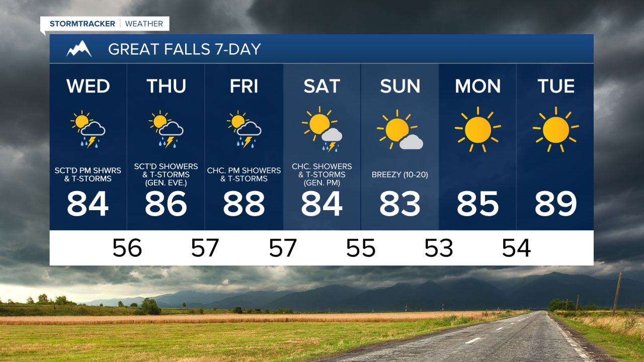
We are going to have mostly clear skies tonight with some isolated showers and thunderstorms around, mainly before midnight and mainly in locations east of I-15. A couple of these thunderstorms may also be severe with 60+ mph wind gusts, 1+” hail, and/or a stray tornado. Flash flooding due to heavy rainfall is also possible with these thunderstorms. Some patchy areas of fog may also develop tonight in locations that saw some precipitation today/see some precipitation this evening/early tonight. It is also going to feel nice outside tonight as lows are going to be in the low to mid 50s in most locations.
For tomorrow and Thursday, we are going to have increasing clouds with scattered showers and thunderstorms around, mainly during the afternoon and evening. There are then going to continue to be scattered showers and thunderstorms around tomorrow night and Thursday night, especially before midnight and generally in locations east of I-15. On both of these days, these showers and thunderstorms are initially going to develop in southwestern Montana. These showers and thunderstorms are then going to trek towards the east and northeast as the day/night goes on, with northeastern Montana seeing the precipitation last.


Frequent lightning, flash flooding due to heavy rainfall, gusty winds, and/or small to medium-sized hail are possible with all thunderstorms that we see tomorrow and Thursday. Some of the thunderstorms that we see tomorrow and Thursday are also going to be severe with damaging winds, large hail, and/or a stray tornado. If you are going to be outside at all over the next few days, please stay weather aware and seek shelter if a thunderstorm is coming your way.
There are then going to be some scattered showers and thunderstorms around on Friday and Saturday, mainly during the PM hours, as we remain in an active weather pattern. Some of the thunderstorms that we see on these two days may also be severe with damaging winds, large hail, and/or a stray tornado. Flash flooding due to heavy rainfall is also possible during these two days. We are also going to have increasing clouds on these two days, with mostly to mainly sunny skies during the morning and partly to mostly cloudy skies during the afternoon and evening.
It is going to be warm on Wednesday, Thursday, Friday, and Saturday, as highs are going to be in the 80s in most locations, and a few locations may even top out in the low 90s on Friday. There is also not going to be much wind around on Wednesday, Thursday, and Friday, as sustained wind speeds are going to be between 5 and 15 mph. On Saturday, there is going to be a little bit of a breeze around as sustained wind speeds are going to be between 5 and 20 mph.
We are then going to have partly cloudy to mostly sunny skies and mostly dry conditions on Sunday, and mainly sunny skies and dry conditions on Monday and Tuesday as high pressure is going to be in control of our weather. On Sunday, it is going to be breezy and warm as sustained wind speeds are going to be between 10 and 20 mph, and highs are going to be in the low to mid 80s in most locations. It is then going to be very warm/hot on Monday and Tuesday as highs are going to be in the 80s on Monday, and the mid to upper 80s and low 90s on Tuesday.