A WINTER STORM WARNING is in effect for the Rocky Mountain Front and some adjacent locations as well as the mountains in central and southwestern Montana from 11pm Friday until 5pm Sunday. 3 to 12 inches of snow accumulation is possible.
A WINTER WEATHER ADVISORY is in effect for some areas west of I-15 from this evening/tonight through 11am/1pm/5pm Sunday. Up to 4 inches of snow accumulation is possible in the lower elevations, and 3 to 10 inches of snow accumulation is possible at and above mountain pass level.
A WINTER WEATHER ADVISORY is in effect for some locations around and east of I-15, including Great Falls and Helena, from 11am/12pm Saturday until 5pm Sunday. 1 to 6 inches of snow accumulation is possible.

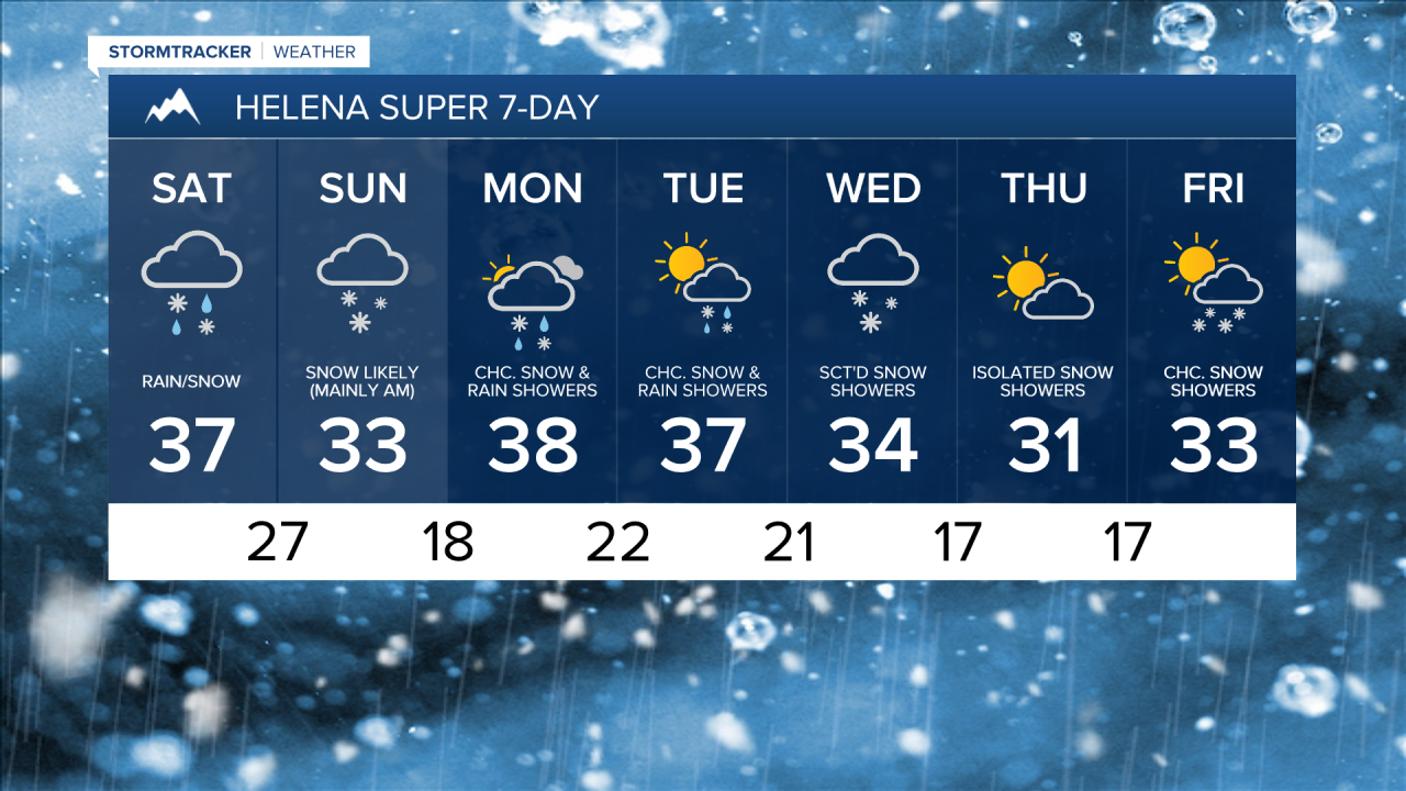
Rain and snow is likely tonight along and west of the Continental Divide as well as around the Helena area. In north-central Montana, there is going to be a little rain and snow around tonight, generally west of I-15. It is also going to be mild again tonight as lows are going to be in the 30s and mid to upper 20s. We are also going to have overcast skies tonight.
There are then going to be areas of precipitation around throughout the day tomorrow (especially in central Montana and western portions of north-central Montana), with the precipitation becoming more widespread as the day goes on. In the lower elevations, precipitation will start out as rain, but this rain will gradually mix in with and switch over to snow (generally from west to east) as we go through tomorrow.
Widespread precipitation is then likely tomorrow night. This precipitation will be in the form of rain in northeastern Montana; rain transitioning to snow in eastern portions of north-central Montana; and snow in western portions of north-central Montana as well as around the Helena area. Snow is then likely on Sunday in north-central and central Montana, but this snow will gradually taper off as the day goes on. In northeastern Montana, rain, possibly mixing in with some snow, is likely on Sunday.
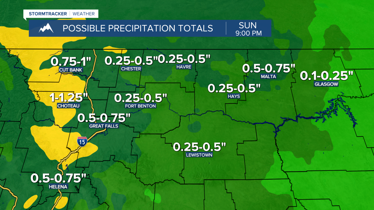
The highest snow amounts this weekend are going to be in the mountains as well as in locations along the Rocky Mountain Front and out to I-15, where 3 to 12 inches of snow accumulation is expected. Around and just east of I-15, a general 1 to 6 inches of snow accumulation is expected. The snow accumulation will then continue to get lower the further east in the state you go, with little to no snow accumulation expected in northeastern Montana. Also, the total precipitation this weekend (which includes the rain and the liquid equivalent of the snow) will be between .25” and 1.25” in most of north-central and central Montana.

The temperatures are also going to cool back down this weekend as highs are going to be in the mid to upper 30s and low to mid 40s tomorrow and the 30s and mid to upper 20s on Sunday. We are also going to have increasing wind in northwestern portions of north-central Montana tomorrow. It is then going to be breezy in portions of north-central Montana tomorrow night and Sunday as sustained wind speeds are going to be between 10 and 25 mph.
On Monday, we are going to have partly to mostly cloudy skies with a chance to see a few snow and rain showers, generally during the afternoon/evening and especially in the mountains. There are then going to be some scattered snow and rain showers around on Tuesday, especially in the mountains. We are also going to have partly to mostly cloudy skies on Tuesday. We are also going to have a wide range of temperatures on these two days as highs are going to range from the mid 20s to the mid 40s.
There are then going to be scattered snow showers around on Wednesday as a stronger disturbance passes through our area. Some lingering snow showers are then possible on Thursday as this disturbance leaves our area. We are also going to have mostly cloudy skies on Wednesday and partly cloudy skies on Thursday. The temperatures on these two days are also going to be near average for this time of year as highs are going to be in the low to mid 30s in most locations. There is also going to be a little breeze around in some areas on these two days as sustained wind speeds are going to be between 5 and 20 mph.
We are then going to have partly cloudy skies on Friday with a few snow showers around, especially in the mountains, as another disturbance passes through our area. It is also going to be a bit breezy in some areas on Friday as sustained wind speeds are going to be between 10 and 20 mph. Also, highs on Friday are going to be in the upper 20s and low to mid 30s in most locations.