


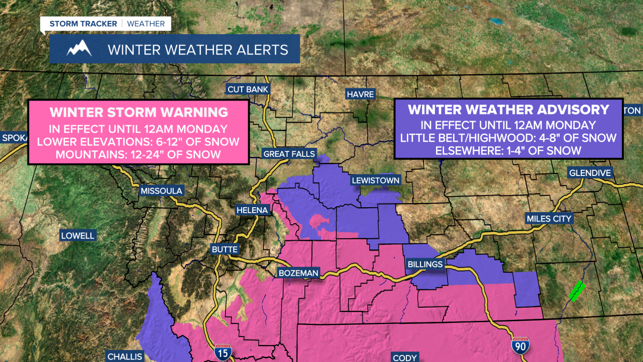
A WINTER STORM WARNING is in effect for portions of southern Montana and some of the mountains in central Montana until 12am Monday. In the lower elevations, 6 to 12 inches of snow accumulation is expected. In the mountains, 12 to 24 inches of snow accumulation is expected.
A WINTER WEATHER ADVISORY is in effect for portions of central Montana until 12am Monday. In the Highwood and Little Belt Mountains, 4 to 8+ inches of snow accumulation is expected. Elsewhere, 1 to 4 inches of snow accumulation is expected.
Periods of snow are expected from tonight through Sunday around the Helena area. In north-central Montana, there are going to be some scattered areas of snow around from tonight through Sunday, generally along the Rocky Mountain Front and in Cascade County, Fergus County, and Judith Basin County. Elsewhere in north-central Montana, little to no snow is expected this weekend. We are also going to have mostly cloudy to overcast skies from tonight through Sunday.
Around the Helena area, 1 to 5 inches of snow accumulation is expected in most of the lower elevations, and 6 to 24 inches of snow accumulation is expected in the mountains, especially east of I-15.

Along the Rocky Mountain Front and in Cascade County, Fergus County, and Judith Basin County, a coating to 4 inches of snow accumulation is expected in the lower elevations, with up to a foot of snow accumulation possible in some of the mountains. Finally, north of Great Falls and east of I-15, less than an inch of snow accumulation is expected, if you even see snow at all.

It is also going to be breezy in portions of central and north-central Montana tonight and tomorrow as sustained wind speeds are going to be between 10 and 20 mph. Widespread breezy conditions are then expected on Sunday, especially during the afternoon and evening, as sustained wind speeds are going to be between 10 and 25 mph, and wind gusts up to 40 mph are going to be possible at times.
Lows tonight are going to be in the teens and 20s in most locations. For this weekend, highs are going to be in the 30s and mid to upper 20s in most locations.
On Monday, we are going to have decreasing clouds with some isolated snow showers around, generally in the mountains. We are then going to have mostly cloudy skies and mostly dry conditions on Tuesday. On Wednesday, we are going to have partly cloudy skies and mostly dry conditions in north-central Montana, and mostly cloudy skies with a chance of snow around the Helena area. Partly cloudy to mostly sunny skies and mostly dry conditions are then expected on Thursday and Friday.
The temperatures from Monday through Thursday of next week are going to be well below average for this time of year as highs are going to be in the 20s and 30s, with the coldest temperatures along the Hi-Line. It is then going to be a little bit warmer on Friday as highs are going to be in the 30s and 40s. There is also only going to be a little breeze around from Monday through Thursday. Breezy conditions are then expected on Friday as sustained wind speeds are going to be between 10 and 25 mph.


