Upper-level ridging over the area today will break down as troughing moves through Canada. As this occurs, a strong upper-level jet streak will develop over the Northern US, which will result in the development of strong to very strong winds to the Rocky Mountain Front and North Central Plains tonight through Sunday, with gusts of 90-100 mph expected along the Front and gusts in excess of 70 to the Plains. Winds will taper off Sunday afternoon and evening from north to south as a cold front slides in from Alberta.
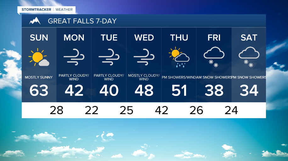
Other than gusty winds Sunday, expect high temperatures in the 50s and 60s with mostly sunny to partly sunny skies. Some low elevation snow and rain will begin from the north, stretching into the plains by Sunday evening. Not much snow accumulation is expected at this time in most lower elevations (<1 inch to 3 inches) but higher elevations are expected to receive more notable accumulation.

Westerly flow Monday and Tuesday will result in cooler but still breezy and unsettled weather with gusty winds on the plains and some light mountain snowfall across the area. Overall, Monday and Tuesday do not look overly impactful, though the continued winds may hamper any recovery work that needs to be done after Sunday.
Our next period of more impactful weather will be Wednesday and Thursday as yet another significant jet streak pushes into the Northern Rockies. A rain and snow mix does look to take place during this period. While there is still naturally quite a bit of uncertainty, it is worth mentioning that there is some potential for Thursday to be a rather significant event for at least portions of the area and for some could produce the strongest wind gusts of the season.
While upper level and surface winds taper off Friday and Saturday, models seem to be in good agreement that a round of snowfall is likely as we close out the week.