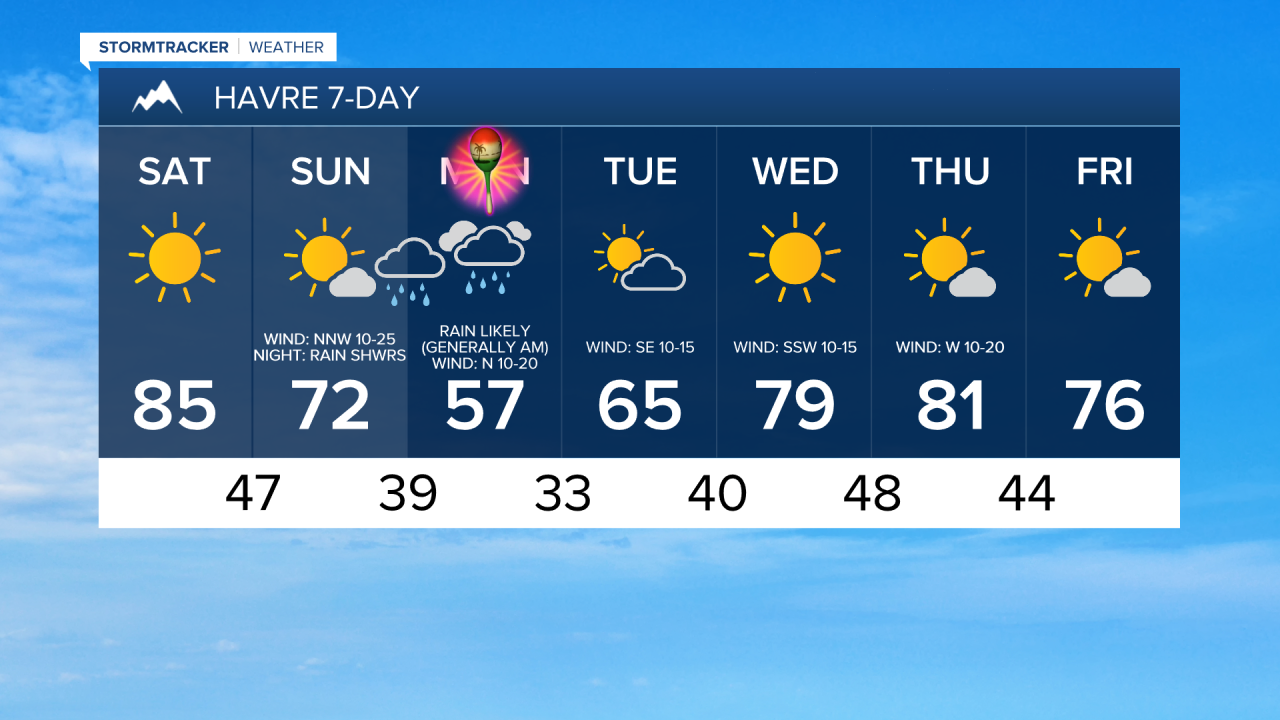
Thanks to an upper-level ridge, we are going to continue to have beautiful weather tonight and tomorrow. Tonight, we are going to have clear skies and pleasant temperatures as lows are going to be in the 40s and upper 30s. For tomorrow, we are going to have lots of sunshine, mainly dry conditions, and little to no wind. Tomorrow is also going to be the warmest day of 2025 so far as highs are going to be in the mid to upper 70s and low to mid 80s. A few locations may even tie or set a new record high temperature tomorrow. Definitely spend as much time outdoors tomorrow as you can!
Changes arrive as we head into Sunday and Monday as an upper-level trough digs into the southwestern U.S. allowing a strong cold front to pass through Montana. On Sunday, we are going to have increasing clouds from west to east (partly to mostly sunny skies overall) with some rain and mountain snow in Glacier County and western Pondera County throughout the day and scattered rain/mountain snow showers and isolated thunderstorms developing around Helena and in western/southern portions of north-central Montana during the late afternoon and evening.
We are also going to have a wide range of temperatures on Sunday as highs are going to range from the mid 40s in western Glacier County to the mid 80s in northeastern Montana. Most locations in north-central Montana will top out in the mid to upper 50s, 60s, and low to mid 70s on Sunday. There is also going to be a good breeze around on Sunday as sustained wind speeds are going to be between 10 and 25 mph, and wind gusts up to 40 mph are possible.
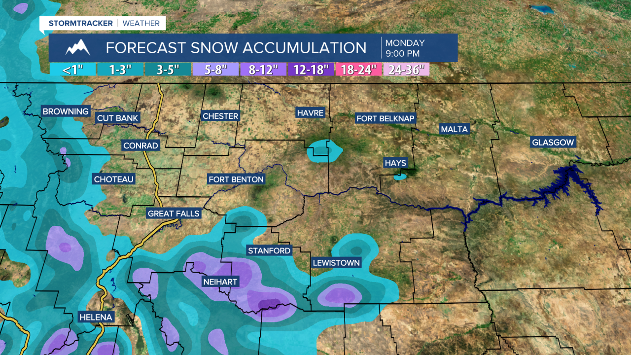
Precipitation will become more widespread in central and north-central Montana as we go through Sunday night. Widespread precipitation is then likely Monday morning, with the precipitation tapering off from north to south as we head into the afternoon and evening. In the lower elevations, precipitation will mainly be in the form of rain, but in the lower elevations near the mountains, including along the Rocky Mountain Front, in between Helena and Butte, through the Dearborn, and in between Belt and Lewistown, a rain/snow mix is expected, with precipitation possibly switching over to just snow for a period of time. In other lower elevation locations, like Great Falls and Helena, a little wet snow may mix in with the rain at times late Sunday night/Monday morning. In the mountains, precipitation will mainly be in the form of snow.
This storm will bring some much needed precipitation to central and north-central Montana. In central Montana and in southern portions of north-central Montana, .25” to 1” of precipitation is expected. In the rest of north-central Montana, .1” to .5” of precipitation is expected in most locations, although a few spots may receive up to .75” of precipitation.
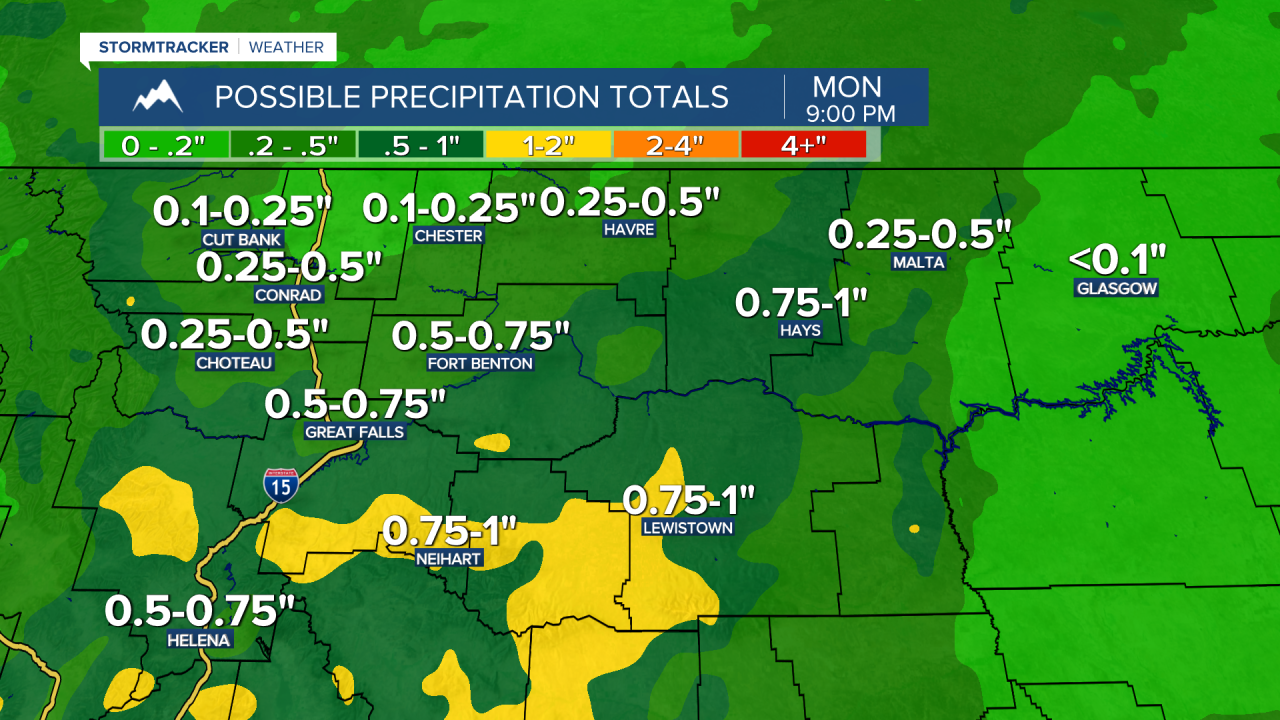
In the lower elevations near the mountains, light snow accumulations of a coating to a couple inches are possible in locations that do see snow. In the mountains, 2-10+” of snow is expected, with the highest snow amounts expected in the Big Belt, Little Belt and Snowy mountains. Travel over some of the mountain passes will be slick Sunday night into Monday morning. Changes to the forecasted precipitation and snow amounts are possible in the coming days due to changes in the storm track, so stay tuned to KRTV/KXLH for the latest updates.
We are also going to have mostly cloudy to overcast skies on Monday and it is going to be cool/chilly on Monday as highs are only going to be in the 40s and low to mid 50s. There is also going to be a breeze around again on Monday as sustained wind speeds are going to be between 10 and 25 mph.
Partly cloudy skies and mostly dry conditions are then expected on Tuesday as Sunday/Monday’s disturbance leaves our area and as an upper-level ridge begins to build back into our area. Lots of sunshine is then expected on Wednesday and mostly sunny skies are expected on Thursday and Friday as this upper-level ridge is going to be in complete control of our weather. It will be dry on Wednesday, but a few isolated showers and storms are possible later in the day on Thursday and Friday.
The temperatures are also going to warm back up between Tuesday and Wednesday as highs are going to be in the mid to upper 50s and low to mid 60s on Tuesday and the 70s on Wednesday. It is then going to be warm on Thursday and Friday as highs are going to be in the 70s and low 80s. There is also only going to be a little breeze around on Tuesday, Wednesday, and Friday as sustained wind speeds are going to be between 5 and 20 mph. On Thursday, it is going to be breezy as sustained wind speeds are going to be between 10 and 20 mph.