


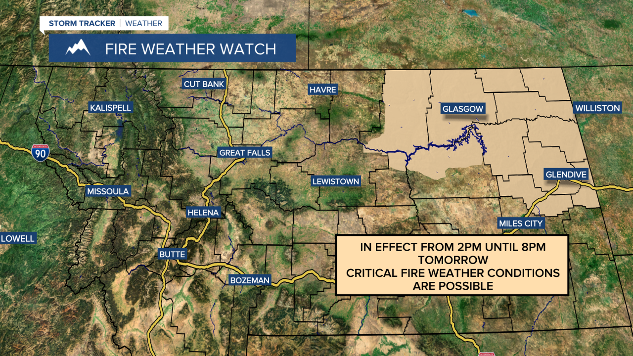
Tomorrow is going to be a transition day of weather as the first of two cold fronts passes through our area. The temperatures tomorrow are still going to be above average for this time of year, but they are going to be cooler than they were today as highs are only going to be in the mid to upper 60s and low 70s. The wind tomorrow is also going to be weaker than it was today, but it is still going to be breezy out there as sustained wind speeds are going to be between 10 and 25 mph, and wind gusts are going to be between 30 and 40 mph. A lot of locations are also going to continue to be dry tomorrow, but there will be a few scattered rain showers around. Elevated fire weather conditions are also expected again tomorrow, especially in the northeastern part of the state, where a Fire Weather Watch is in effect from 2pm until 8pm.
On Sunday, raw weather is expected as the second cold front passes through our area. We are going to have partly to mostly cloudy skies throughout the day on Sunday, and there are going to be scattered valley rain and mountain rain/snow showers around throughout the day on Sunday as well. Even though there will be showers around on Sunday, not a ton of liquid precipitation is expected as most locations are only going to pick up between .05 inches and .2 inches of liquid precipitation, although we will definitely take whatever we can get. It is also going to be even cooler on Sunday than it is going to be tomorrow as highs are only going to be in the mid 50s, and there will continue to be a little bit of a breeze around on Sunday as well as sustained wind speeds are going to be between 5 and 20 mph, and wind gusts are going to be between 20 and 30 mph.
Monday is then going to have partly cloudy to mostly sunny skies with some isolated valley rain and mountain rain/snow showers around as we are going to be in between storm systems. There are then going to be some scattered valley rain and mountain rain/snow showers around on Tuesday as this storm system passes through our area, and some of these showers may linger around into Wednesday. The temperatures on these three days are also going to be near to a little bit below average for this time of year as highs are only going to be in the upper 50s and low to mid 60s. There is also going to be a little bit of a breeze around on Tuesday as sustained wind speeds are going to be between 5 and 20 mph, and wind gusts are going to be between 20 and 30 mph.
Partly cloudy skies and dry conditions are then expected on Thursday as high pressure is going to briefly be in control of our weather. Friday is then going to have partly cloudy skies with a chance of rain showers as another storm system begins to approach our area. The temperatures on these two days are also going to be above average for this time of year as highs on Thursday are going to be in the low to mid 70s, and highs on Friday are going to be in the upper 60s and low 70s. There is also going to be a little bit of a breeze around on these two days as sustained wind speeds are going to be between 5 and 20 mph, and wind gusts are going to be between 20 and 30 mph.


