It is going to be very windy over the next several days as multiple cold and warm fronts pass through our area. From tonight through Tuesday, sustained wind speeds are generally going to be between 15 and 40 mph, and wind gusts up to 60+ mph are going to be possible at times. We will get some breaks in the wind, but those breaks are generally going to be short-lived, with the longest break occurring tomorrow night.
High Wind Watches and Warnings are also in effect for portions of central and eastern Montana from Saturday morning through Saturday evening. I also expect High Wind Watches and Warnings to be issued for parts of Montana for Sunday and Monday. These strong winds are going to create difficult travel conditions for high-profile vehicles. Some power lines and/or tree limbs may also be blown down over the next few days, which may cause there to be some isolated power outages. Additionally, if you have anything that can easily blow away, make sure you tie/weigh it down or bring it inside immediately!

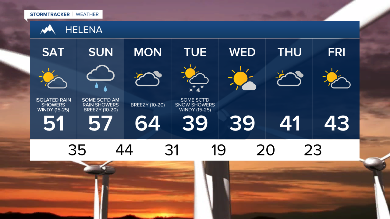
We are going to have mostly cloudy skies tonight, with some clearing after midnight. There are also going to be some scattered valley rain and mountain rain/snow showers around tonight as a warm front leaves our area and as a cold front begins to approach our area. It is also going to be mild tonight as lows are going to be in the 30s and 40s.
For tomorrow, we are going to have partly cloudy skies with a chance of a few valley rain and mountain rain/snow showers, especially during the morning and especially in locations east of I-15, as a cold front passes through our area. There are then going to be scattered rain and snow showers around tomorrow night, and there are going to be some scattered valley rain and mountain rain/snow showers around on Sunday, especially during the morning and especially in locations east of I-15, as a warm front passes through our area. Light snow accumulations are possible in locations that do see some snow. Some sleet and freezing rain is also possible Saturday night and Sunday morning, although little to no ice accumulation is expected. We are also going to have overcast skies on Sunday.
The temperatures this weekend are going to be pretty nice for this time of year as highs on Saturday are going to be in the mid to upper 40s and low to mid 50s, and highs on Sunday are going to be in the 50s. As a reminder though, it is going to be windy this weekend, so it will feel a bit colder than what the actual air temperature is, especially on Saturday.
As we head into Monday, we are going to have partly to mostly cloudy skies and mainly dry conditions as the next cold front begins to approach our area. There are then going to be scattered rain showers around Monday night, and these rain showers will mix in with and eventually switch over to snow behind the cold front. There are then going to be some scattered snow showers around throughout the day on Tuesday. The temperatures are also going to cool down a lot between Monday and Tuesday. On Monday, highs are going to be in the 60s, and some locations may even set a new record high temperature. High temperatures are then only going to be in the upper 30s and low 40s on Tuesday.
For next Wednesday through Friday, there is a slight chance that we could see a few snow and rain showers, but most locations are going to remain dry. We are also going to have mostly sunny skies on Wednesday, and partly cloudy skies on Thursday and Friday. It is also going to be chilly on these three days as highs are going to be in the mid to upper 30s and low to mid 40s. Breezy conditions are also expected from Wednesday through Friday as sustained wind speeds are going to be between 10 and 25 mph.