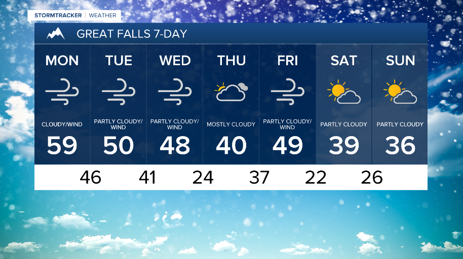
WEATHER DISCUSSION: Stronger winds will continue along the Rocky Mountain Front tonight. Windy conditions become more widespread across the rest of North Central MT starting early Monday morning and continuing roughly through Wednesday. High pressure pushes into the area causing these increasing winds and sets up relatively mild temperatures tonight, especially across the plains with even warmer temperatures across the area Monday.
The biggest concern Monday will be the widespread windy conditions. Strong winds initially redevelop Monday afternoon along the Rocky Mountain Front. Wind gusts could top as high as 80 mph for these locations. The winds will spread east across adjacent portions of North Central MT and peak overnight Monday night as low pressure and an associated upper-level wave track across Canada. High Wind Warnings will begin becoming in effect starting Monday morning and continuing through Tuesday evening at this time.
Otherwise, expect above average temperatures Monday through Wednesday back in the 40s and even 50s for some locations with variable cloud cover and mainly dry conditions.

Wednesday still holds the potential for a particularly widespread/higher end wind event for the area because of a fairly potent shortwave and associated Pacific cold front tracking across the region. This could also bring the potential for more precipitation such as showers and mountain snow.
Cooling behind the Wednesday system is brief with a colder airmass glancing portions of the region Wednesday night. While cooler temperatures than early in the week are expected, temperatures look largely to remain above average into the weekend.