


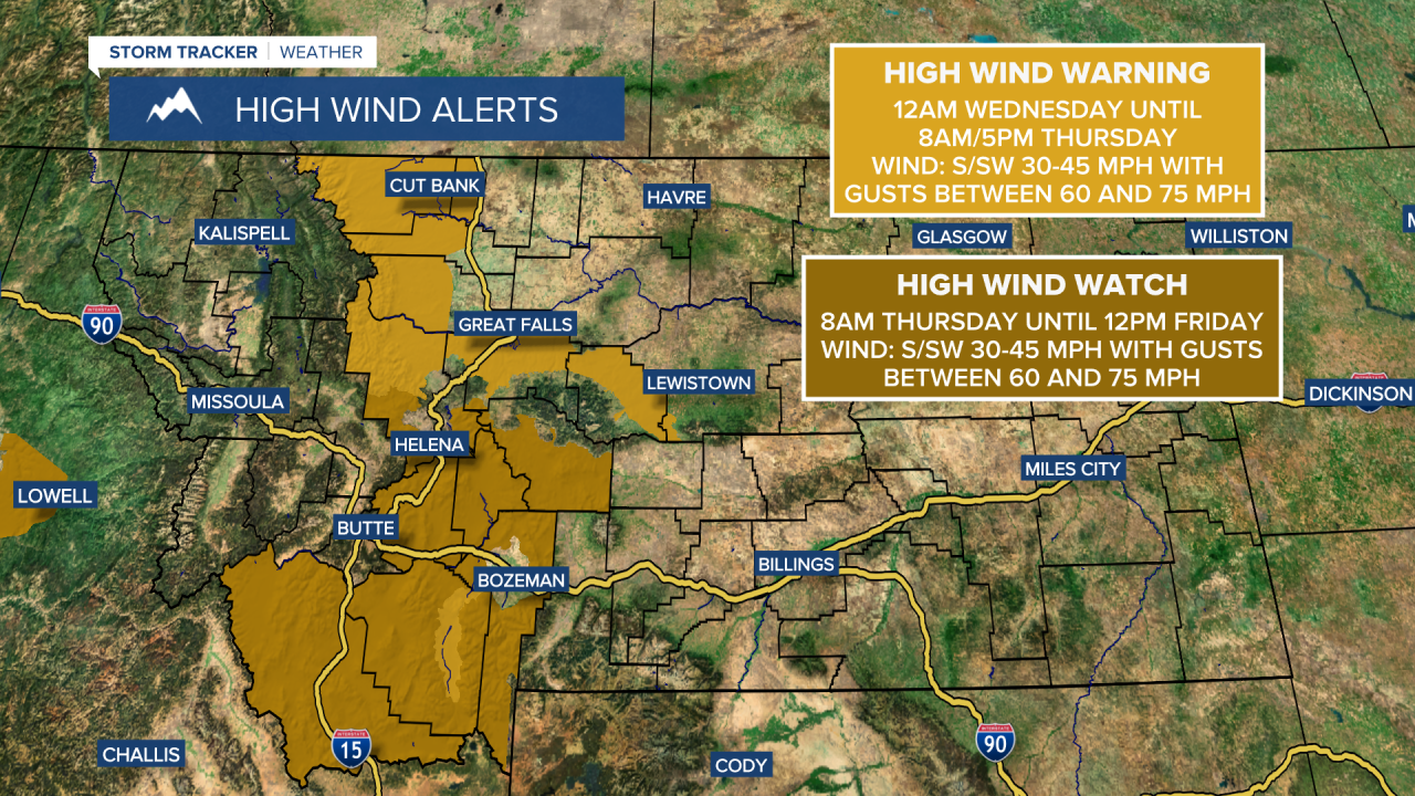
A HIGH WIND WARNING is in effect for the Rocky Mountain Front and adjacent locations; the Madison River Valley; and portions of Cascade County and Judith Basin County from 12am Wednesday until 8am/5pm Thursday.
A HIGH WIND WATCH is in effect for portions of central and southwestern Montana from 8am Thursday until 12pm Friday.
A WINTER STORM WARNING is in effect for the Lower Clark Fork region in western Montana from 2am until 5pm Wednesday.
A WINTER WEATHER ADVISORY is in effect for the Kootenai/Cabinet region in northwestern Montana from 2am Wednesday until 5pm Wednesday.
A WINTER WEATHER ADVISORY is in effect for the West Glacier area from 5am Wednesday until 2pm Thursday.
A WINTER WEATHER ADVISORY is in effect for the Livingston area from 12am until 12pm Wednesday.

We are going to have increasing wind tonight, with widespread gusty to strong winds around on Wednesday and Thursday. Along the Rocky Mountain Front, sustained wind speeds are going to be between 25 and 50 mph, and wind gusts over 70 mph are possible (especially tomorrow). East of the Rocky Mountain Front, sustained wind speeds are going to be between 10 and 35 mph, and wind gusts over 50 mph are possible. This is also going to be a warmer wind as it is going to be coming out of the south or southwest in most locations.
Lows tonight are going to be in the single digits and teens, but in several locations, these low temperatures will occur early on tonight, with rising temperatures the rest of the night. It is then going to be a lot warmer tomorrow and Thursday than it was today as highs are going to be in the 40s and upper 30s tomorrow and the 50s and mid to upper 40s on Thursday. A few spots may even reach 60° on Thursday.
We are also going to have partly to mostly cloudy skies tonight and tomorrow with some snow along the Divide and isolated snow/rain showers east of the Divide. We are then going to have partly to mostly sunny skies on Thursday with scattered precipitation around Thursday evening and Thursday night as a cold front passes through our area. This precipitation may start out as rain in the lower elevations, but will quickly switch-over to snow.
Snow showers are then likely on Friday around Helena and a few scattered snow and rain showers are possible in north-central Montana on Friday as another disturbance impacts our area. We are also going to have partly to mostly cloudy skies and colder temperatures on Friday as highs are going to be in the mid to upper 30s and low to mid 40s. It is also going to be breezy in some areas on Friday as sustained wind speeds are going to be between 10 and 20 mph.
Widespread snow is then likely on Saturday as a storm system passes through our area. A little rain may also mix in with this snow initially in eastern portions of north-central Montana. Snow is then likely on Sunday around Helena, and there is going to be some scattered snow around on Sunday in north-central Montana. We are also going to have mostly cloudy skies this weekend.
The temperatures are also going to continue to cool down this weekend as highs are going to be in the 20s and low to mid 30s on Saturday and the mid to upper teens and low to mid 20s on Sunday. There is also going to be a bit of a breeze around in some areas this weekend as sustained wind speeds are going to be between 10 and 20 mph.
On Monday, there are going to be scattered snow showers around Helena and isolated snow showers around in north-central Montana. Some more isolated snow showers are then possible on Tuesday, especially in the mountains. We are also going to have partly cloudy skies on these two days. The temperatures are also going to warm back up some over these two days as highs are going to be in the 20s and low 30s on Monday and the 30s and mid to upper 20s on Tuesday. There is also going to be a breeze around in some areas on these two days as sustained wind speeds are going to be between 10 and 20 mph.


