A FLOOD WATCH is in effect for portions of southern and eastern Montana until 12am/6am Saturday. Flooding due to excessive rainfall is possible.

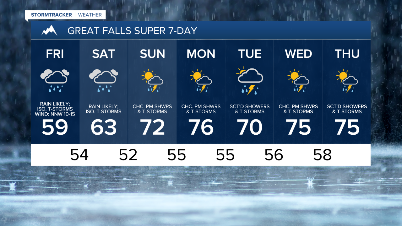
There are going to be scattered showers and thunderstorms around tonight, especially in locations east of I-15. As we go through tomorrow morning, the precipitation is going to become more widespread within the central part of the state and periods of rain are expected tomorrow, tomorrow night, and Saturday as a disturbance lingers over our area. Some of the rain that falls from this evening through Saturday may also be heavy at times, especially in locations east of I-15.
For tomorrow, there is a MODERATE risk for excessive rainfall in portions of north-central and northeastern Montana, which means that there is a 40+% chance to see flash flooding within 25 miles of a given location in that area. Other parts of Montana are under a SLIGHT risk to see excessive rainfall, which means that there is a 15+% chance to see flash flooding within 25 miles of a given location in those areas. If a road is flooded, make sure you turn around and don’t drown.

The lowest rainfall amounts through Sunday morning are likely going to be in locations west of I-15 in north-central Montana, while the highest rainfall amounts are likely going to be in locations east of I-15. West of I-15 in north-central Montana, up to a half inch of rainfall is possible. Around I-15, generally between a quarter inch and an inch of rainfall is expected. East of I-15, a half inch to 2 inches of rainfall is expected, with a few locations potentially receiving over 2 inches of rainfall.

Please note that there is still some uncertainty with the models on just how far west the precipitation is going to be over the next two days, which could impact how much rain falls in locations around and west of I-15.
It is also going to be cool tomorrow and Saturday as highs are going to be in the 50s and 60s in most locations. There is also going to be a bit of a breeze around tomorrow as sustained wind speeds are going to be between 10 and 20 mph, and this wind is going to be coming out of the north.
Sunday is going to be the nicer day of the weekend as we are going to have mostly to partly cloudy skies and warmer temperatures as highs are going to be in the 70s and upper 60s. It is also not going to be as wet as tomorrow and Saturday are going to be, but there will still be some scattered showers and thunderstorms around during the second half of the day.
We are then going to have increasing clouds on Monday with a chance of showers and thunderstorms during the afternoon and evening. There are then going to be scattered showers and thunderstorms around on Tuesday as another disturbance passes through our area. On Monday, highs are going to be in the 70s and low to mid 80s in most locations. It is then going to be a little cooler on Tuesday as highs are going to be in the 70s and upper 60s in most locations (low to mid 80s in northeastern Montana).
There are then going to be some more scattered showers and thunderstorms around on Wednesday and Thursday as a few more disturbances pass through our area. It is also going to be mild on these two days as highs are going to be in the 70s in most locations (80s in northeastern Montana).