

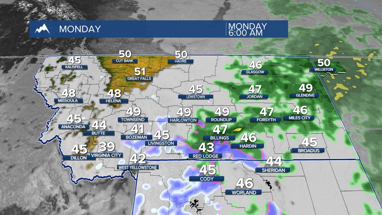


MONTANA — A very wet start to November will continue through Monday, especially across eastern and southeast Montana and northern Wyoming. Mountain snow, strong winds and areas of fog will create additional travel concerns before much of Montana turns milder and drier beginning Tuesday.
SUNDAY NIGHT
Rain will continue expanding across Montana tonight as a moisture-rich storm moves through the Northern Rockies. The heaviest rainfall will focus on south-central and southeast Montana, where areas south and east of Billings could pick up roughly 0.75 to 1.5 inches total. Rain will also become widespread across northeast Montana, while western Montana will see the greatest precipitation along and south of I-90.
Snow levels will fall overnight, bringing accumulating snow to the higher mountains. The Absaroka-Beartooths could receive 4 to 8 inches, with 5 to 10 inches in the Bighorns and locally higher amounts possible.
Higher terrain around southwest Montana, particularly the Madison and Gallatin ranges, will also see accumulating snow. Most lower elevations should remain rain, although snow levels may briefly reach some valley floors by Monday morning.
Fog and low clouds will remain another concern. Areas of western, central, north-central and southwest Montana could see fog redevelop overnight as winds become lighter and plenty of low-level moisture remains in place.
MONDAY
Rain will remain widespread across eastern Montana during the morning before gradually ending from west to east. Southeast Montana could finish the storm with unusually high precipitation totals for early November, while northern Wyoming could receive around a half-inch to an inch of rain in some locations.
The wind will become a bigger story behind the storm. Northwest gusts of 25 to 45 mph will become common across south-central and southeast Montana, with some gusts reaching 50 mph or higher across far southeast Montana and northern Wyoming. Combined with heavy mountain snow, this could make travel particularly difficult across the Bighorns, including Highway 14.
Farther west and north, precipitation will diminish during the morning. Patchy fog and stubborn low clouds could linger across valleys of southwest, central and north-central Montana, potentially holding afternoon temperatures several degrees lower than expected.
TUESDAY
A quieter pattern takes over statewide as high pressure builds across the region. Most areas will be dry with temperatures generally returning to seasonable or slightly milder levels.
Billings and much of south-central Montana should climb into the 50s, with similar warming occurring across central and north-central Montana.
The main exception may be morning valley fog and low clouds, particularly across western, central and southwest Montana. Where fog is persistent, temperatures could remain cooler than surrounding areas.
WEDNESDAY
Generally mild and dry weather continues for most of Montana and northern Wyoming. A weak disturbance could produce an isolated shower over southwest Montana or near the Continental Divide, but widespread precipitation is not expected. Valley fog and low clouds could again develop during the morning.
THURSDAY
Most of central and eastern Montana should stay mild and dry. Western Montana has a somewhat better chance of seeing a few showers as a quick-moving disturbance passes through, with light mountain snow possible around 5,000 feet in northwest Montana.
FRIDAY
The generally mild pattern continues, but another Pacific disturbance may begin approaching the Northern Rockies. Western Montana has the greatest chance of seeing precipitation return, while central Montana could become somewhat windier. South-central and eastern Montana should remain mainly dry.
NEXT WEEKEND
Forecast confidence decreases, but there are indications that the pattern could become more active again. Western Montana has a chance for renewed precipitation and mountain snow, while eastern Montana may also see another opportunity for precipitation during the weekend. Despite the disturbances, the broader pattern favors relatively mild air across the region.
