


A BLIZZARD WARNING is in effect for the Flathead Valley, Mission Valley, Flathead Lake, and Polson until 5am Thursday. Heavy snow and blowing snow will lead to whiteout conditions. Total snow accumulation of 8 to 14 inches is expected.

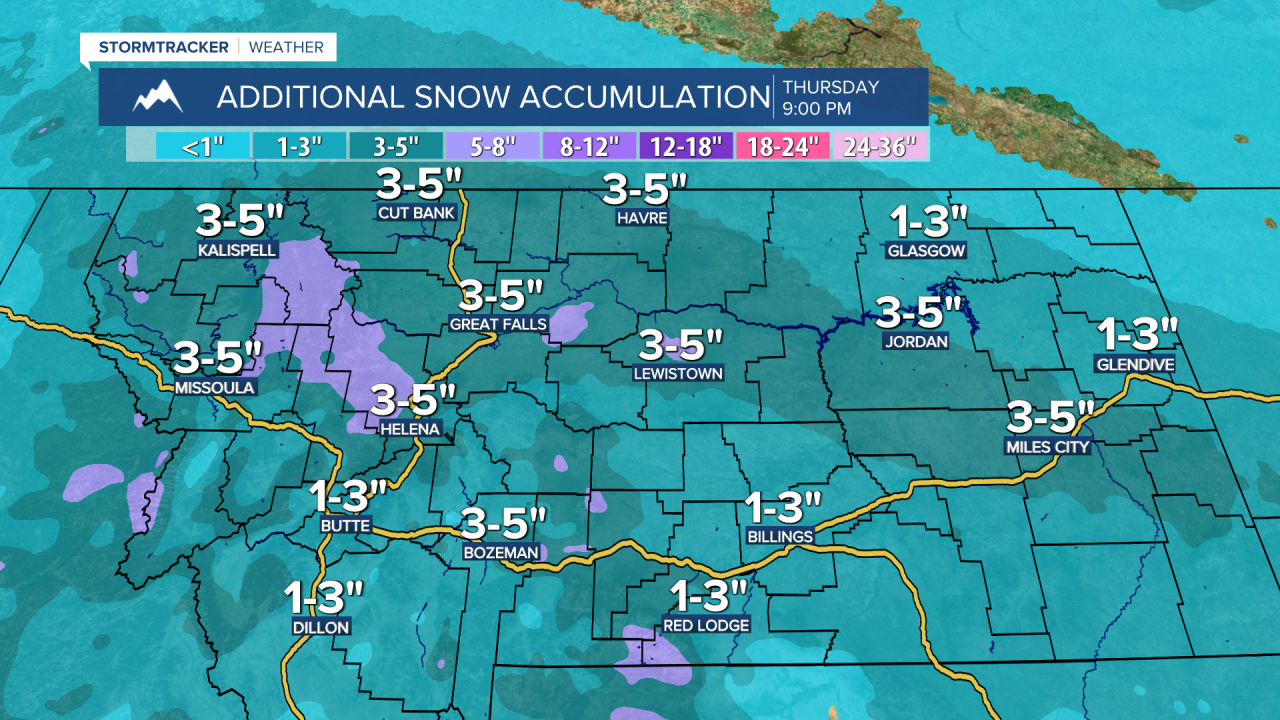
A WINTER STORM WARNING is in effect for western Montana, north-central Montana, and portions of south-central and southeastern Montana until 11am/5pm Thursday. In western Montana, 3 to 16 inches of total snow accumulation is expected in the lower elevations and 12 to 24 inches of total snow accumulation is expected in the mountains. Elsewhere, 3 to 10 inches of new snow accumulation is expected in the lower elevations and 6 to 13 inches of new snow accumulation is expected in the mountains.

A WINTER WEATHER ADVISORY is in effect for portions of eastern and south-central Montana until 11am/5pm Thursday. 1 to 5 inches of new snow accumulation is expected.

A WIND CHILL ADVISORY is in effect for all of northeastern Montana until 11am Friday and for all of north-central Montana and portions of central Montana until 5pm Thursday or 8am/12pm Friday. Wind chills as low as -30° to -45° are possible.

Widespread light to moderate snow is likely this evening and early tonight. Some of this snow may also be heavy at times. This snow is then going to gradually taper off after midnight, and most of the snow will be out of the state by sunrise tomorrow. In most of Montana, 1 to 8 inches of new snow accumulation is expected by midday tomorrow. If you are going to be traveling anywhere this evening, tonight, or tomorrow morning, please use extreme caution and give yourself some extra time to get to where you need to go as roads are going to be slick and/or snow-covered throughout much of the state.
It is also going to be breezy in some areas tonight as sustained wind speeds are going to be between 10 and 20 mph, and this wind will cause there to be areas of blowing and drifting snow around. Frigid temperatures are also expected tonight as lows are going to be in the -0s and low to mid -10s, and wind chills are going to be in the -0s, -10s, and -20s in a lot of locations.
For tomorrow, we are going to have partly cloudy skies with a few isolated snow showers around during the morning. It is also going to be breezy tomorrow in eastern portions of north-central Montana as sustained wind speeds are going to be between 10 and 25 mph. Frigid temperatures are also expected tomorrow as highs are going to be in the 0s and -0s, and wind chills as low as -30° to -45° are possible.
Snow showers are then likely on Friday around the Helena area, and a few scattered snow showers are possible in north-central Montana on Friday as another disturbance passes through our area, and light snow accumulations are possible. We are also going to have mostly cloudy skies on Friday. It is also going to be cold on Friday in north-central Montana as highs are going to be in the 0s and low to mid 10s in most locations, and it is going to be warmer on Friday than it will be tomorrow in central Montana as highs are going to be in the mid to upper teens and low to mid 20s in most locations.
We are then going to have mostly cloudy skies on Saturday with some scattered snow and rain showers around the Helena area, generally during the evening, and a few isolated rain and snow showers around in north-central Montana as another disturbance passes through our area. It is also going to be warmer for everyone on Saturday as highs are going to range from the upper teens to the low 40s. There is also going to be a little bit of a breeze around on Saturday as sustained wind speeds are going to be between 5 and 20 mph.
Partly cloudy skies and mostly dry conditions are then expected from Sunday through Wednesday as high pressure is going to be in control of our weather. We are also going to have near to above average temperatures on these four days as highs are going to range from the mid 20s to the mid 40s, with the coldest temperatures along the central and eastern half of the Hi-Line. It is also going to be breezy in some areas on these four days as sustained wind speeds are going to be between 10 and 20 mph.


