A HIGH WIND WARNING is in effect for most of north-central Montana and portions of central Montana until 12pm Wednesday.

A LAKE WIND ADVISORY is in effect for Fort Peck Lake from 12am Tuesday until 10pm Wednesday.

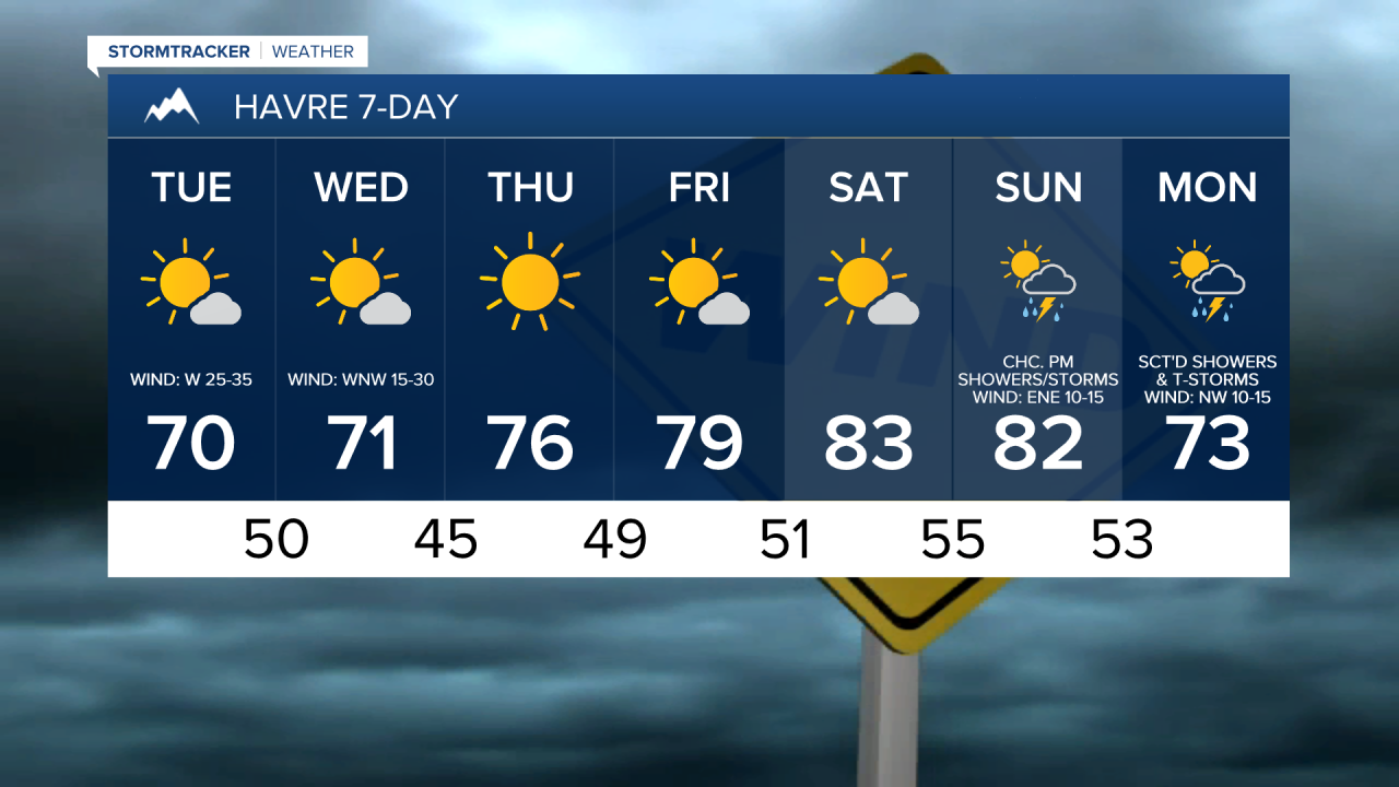
Windy conditions are expected through Wednesday, with the strongest wind expected during the day on Tuesday. Wind gusts up to 80 mph are possible along the Rocky Mountain Front and along the Hi-Line between the Divide and I-15, and wind gusts up to 65 mph are possible everywhere else (with widespread wind gusts over 40 mph likely). Sustained wind speeds in most locations through Wednesday will be between 15 and 40 mph. The weakest wind over the next couple of days will be in the valleys (including Helena and Townsend), but wind gusts up to 40 mph are still possible in those areas with sustained wind speeds between 10 and 30 mph. Also, the wind will be coming out of the west in most locations over the next few days.

There are going to be scattered showers and thunderstorms around this evening and tonight, mainly in locations east of I-15, as a cold front continues to pass through our area. We are also going to have partly cloudy skies tonight. For tomorrow, we are going to have partly to mostly sunny skies in north-central Montana and mostly cloudy skies around Helena. There are also going to be some isolated showers around tomorrow, generally in the mountains and in northeastern Montana. We are then going to have lots of sunshine and mainly dry conditions on Wednesday. It is also going to be cool tonight as lows are going to be in the 40s and upper 30s. We are then going to have seasonable temperatures tomorrow and Wednesday as highs are going to be in the 60s and low to mid 70s in most locations, with Wednesday being the warmer day.
Lots of sunshine and mainly dry conditions are then expected from Thursday through Saturday as high pressure is going to be in control of our weather. We are also going to have little wind and very warm temperatures on these three days as sustained wind speeds are going to be between 5 and 20 mph, and highs are going to be in the 80s and mid to upper 70s, with Saturday being the warmest day of these three days.
We are then going to have increasing clouds with some scattered PM showers and thunderstorms around on Sunday as a disturbance begins to pass through our area. Showers and thunderstorms are then likely on Monday as another disturbance passes through our area. We are also going to have partly cloudy skies on Monday. The temperatures are also going to cool down a little bit over these two days as highs are going to be in the mid to upper 70s and low to mid 80s on Sunday and the low to mid 70s on Monday. It is also going to be breezy on Monday as sustained wind speeds are going to be between 10 and 20 mph.