


A Dense Fog Advisory is in effect for Cascade County, Fergus County, Judith Basin County, northern Lewis and Clark County, and Teton County until 12pm Thursday. Visibility of 1/4 mile or less is possible. Also, with temperatures near or below freezing, some of this fog may create icy spots on paved surfaces.

A Winter Weather Advisory is in effect until 5am Friday for the Hi-Line and some counties south of the Hi-Line. Below 5500 feet, up to .1 inches of ice accumulation and up to 3 inches of snow accumulation is possible. Above 5500 feet, up to 8 inches of snow accumulation is possible. Slick roads are also expected due to this snow and ice, so please be careful when driving.

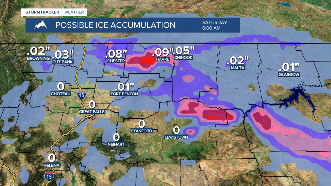
A wintry mix of rain, freezing rain, sleet, and snow is likely this evening and tonight, especially in locations along of the Hi-Line. This wintry mix will then gradually end tomorrow morning. We are then going to get a bit of a break in the precipitation during the middle part of tomorrow, but another round of precipitation will begin to work its way through north-central Montana tomorrow evening and tomorrow night. This precipitation may initially begin as a wintry mix of rain, freezing rain, sleet, and snow, but should quickly transition over to all snow. On Friday, there are going to be areas of snow around, especially in locations south of the Hi-Line. There are then going to continue to be areas of snow around Friday night, but most of this snow should be out of our area by sunrise on Saturday.
Between this evening and Saturday morning, a general coating to 4 inches of snow accumulation is expected in the lower elevations, and up to 8 inches of snow accumulation is possible in the higher elevations. Up to a tenth of an inch of ice accumulation is also possible between this evening and Saturday morning, especially in locations along of the Hi-Line. For locations south of the Hi-Line, most of this snow and ice accumulation is going to occur Thursday night through Saturday morning. For locations along the Hi-Line, this snow and ice accumulation is going to come in two rounds, with the first round occurring this evening through tomorrow morning, and the second round occurring Thursday night. Slick roads are also expected over the next few days, so please be careful when driving and give yourself some extra time to get to where you need to go.

It is going to be chilly tonight along the Hi-Line as lows are going to be in the 20s, and it is going to be cool tonight in locations south of the Hi-Line as lows are going to be in the low to mid 30s. For tomorrow, it is going to be chilly along the Hi-Line as highs are going to be in the low to mid 30s, and it is going to be cool/mild in locations south of the Hi-Line as highs are going to be in the mid to upper 40s and low to mid 50s. Chilly temperatures are then expected for everyone on Friday as highs are going to be in the mid to upper 20s and low to mid 30s.
On Saturday, we are going to have mostly cloudy skies with a slight chance of snow showers during the morning. We are then going to have partly cloudy skies and mostly dry conditions on Sunday and Monday as high pressure is going to be in control of our weather. It is also going to be chilly on Saturday as highs are going to be in the 20s. The temperatures are then going to warm up some for Sunday and Monday as highs on Sunday are going to be around freezing and highs on Monday are going to be in the upper 30s and low to mid 40s. Breezy conditions are also expected on Monday as sustained wind speeds are going to be between 10 and 20 mph.
There are then going to be some scattered snow showers around on Tuesday and Wednesday, especially from Tuesday afternoon through Wednesday morning, as a storm system passes through our area. The temperatures are also going to cool back down over these two days as highs on Tuesday are going to be in the mid to upper 30s and low 40s, and highs on Wednesday are going to be in the mid to upper 20s and low 30s. It is also going to be breezy on Tuesday as sustained wind speeds are going to be between 10 and 20 mph.
TRENDING ARTICLES
- Great Falls movie-rental store is closing
- Large GFPD response on 10th Avenue South
- What do those "AkidaK" billboards mean?
- Obituary: Neil John Burkstrand
- GF woman shines light on rare diseases


