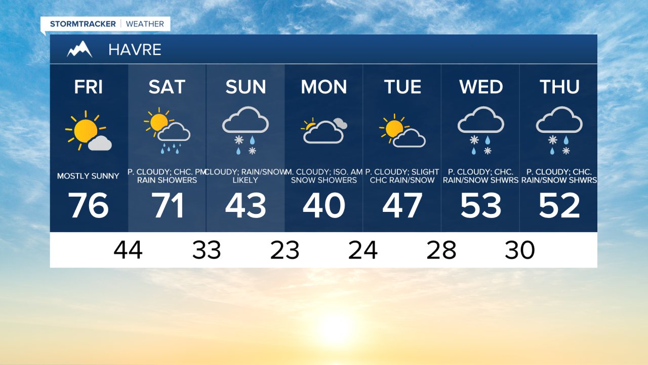
Enjoy our last day in the 70s for a while! There are a few showers near Helena this morning, but these will dissipate, and mostly sunny skies are in the forecast for central and eastern Montana. Breezy conditions will develop east of Havre on the Hi-Line, with wind speeds between 10 and 20 mph throughout the afternoon and evening.
Check out the forecast:
A winter storm moves in this weekend for the mountains. The bulk of the snow will fall from Saturday night through Monday morning, which could cause difficult travel conditions at and above mountain pass levels. The first light snowfall of the season is possible for lower elevations on Sunday.
The precipitation becomes more widespread Saturday night as the low pressure system starts to move over the state. Rain and mountain snow will begin in northwest Montana and Glacier National Park and then spread southeast across the region. Snow levels will lower from Saturday night into Sunday, affecting lower elevations.

Mountain snow continues on Sunday, and there will be periods of rain and snow in the lower elevations Temperatures will be around 20 to 30 degrees cooler on Sunday, with high temperatures in the 30s and 40s. Snow levels drop to around 3,000 to 4,000 feet, so many lower-elevation areas, including Great Falls, could see some snow.


A gusty breeze will also accompany the cold weather as wind speeds will be between 10 and 25 mph out of the northwest, with gusts up to 40 mph for the Rocky Mountain Front and 30 mph across the plains.
Areas of light snow, mixed with a little bit of rain, will be around Sunday night into Monday morning in central and western Montana. On Monday, the snow will taper off but a chilly airmass remains with highs in the 30s and low 40s.
The mountains will receive moderate to heavy snowfall Saturday evening through Monday morning. In Glacier National Park and for the immediate Rocky Mountain Front, 6-12 inches of snow is expected above 6,000 feet and 2-6 inches of snow below 6,000 feet. The Little Belts, Highwoods and Snowies will pick up 4-12 inches of snow.
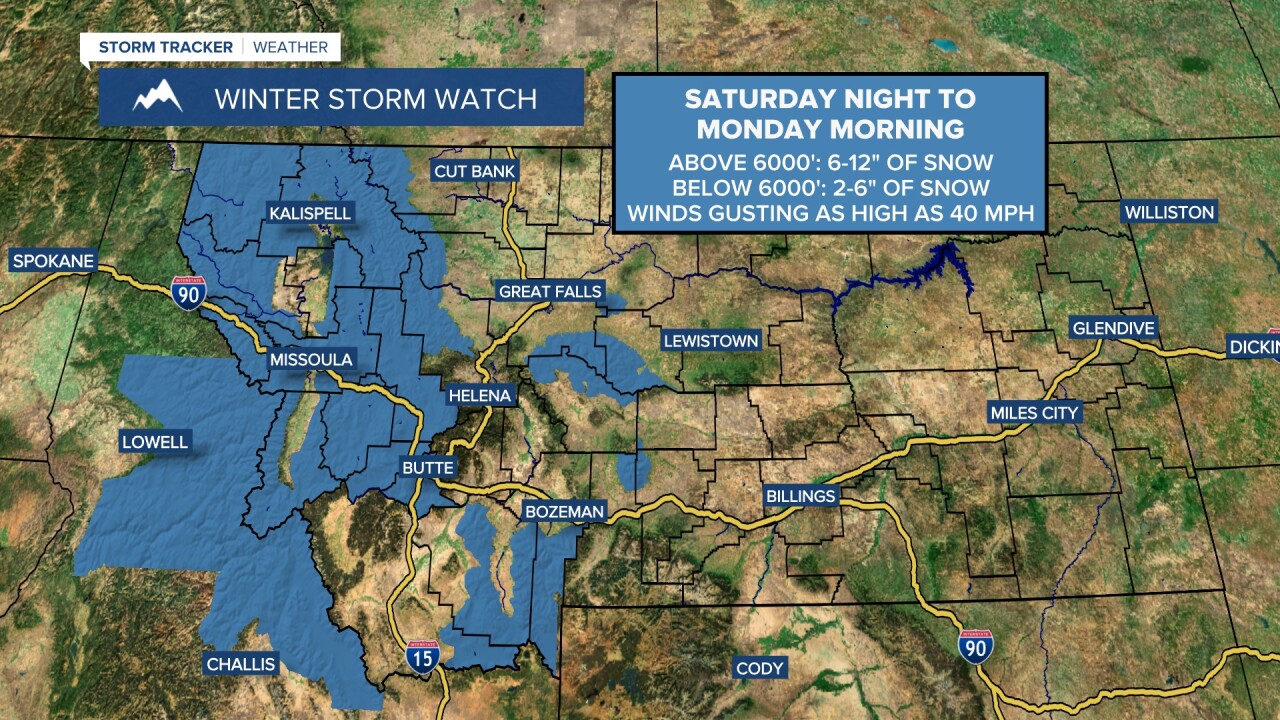
A Winter Storm Watch is in effect for the mountains from Saturday evening through Monday morning. Travel over mountain passes may be difficult, so be sure to check road conditions before heading out.
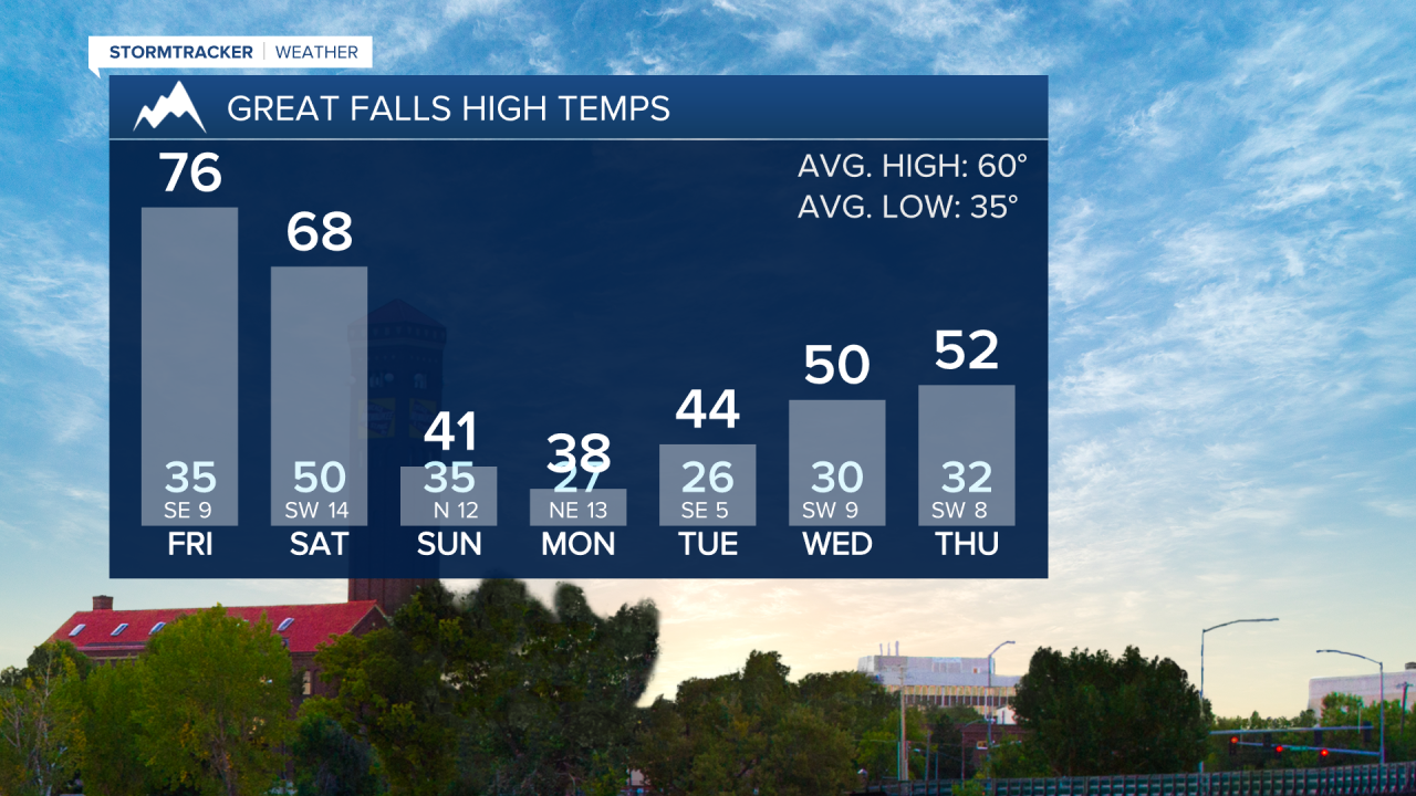
Temperatures will gradually warm through the middle of next week, reaching into the upper 40s and lower 50s by Wednesday and Thursday.