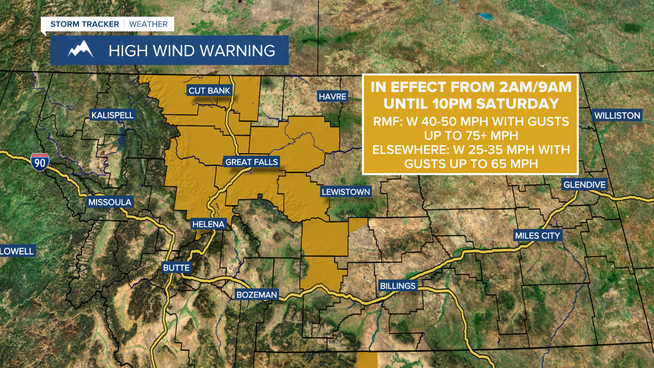
A High Wind Warning is in effect for the Rocky Mountain Front and all of Glacier County from 2am until 10pm Saturday. Sustained wind speeds are going to be between 40 and 50 mph, and wind gusts up to 75+ mph are going to be possible at times.
A High Wind Warning is in effect for some locations east of the Rocky Mountain Front from 9am until 10pm Saturday. Sustained wind speeds are going to be between 25 and 35 mph, and wind gusts up to 65 mph are going to be possible at times.
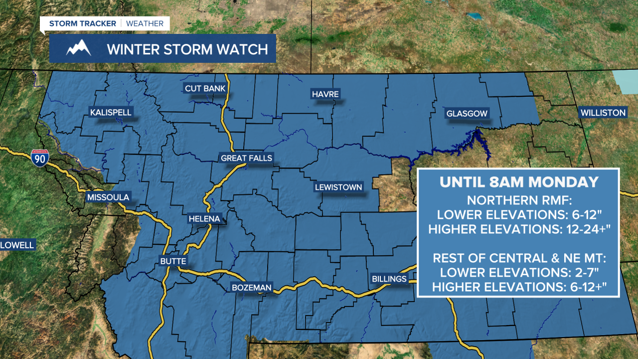
A Winter Storm Watch is in effect for the northern Rocky Mountain Front from 11am Saturday until 8am Monday. 6 to 12" of snow accumulation is possible in the lower elevations, and 12 to 24+" of snow accumulation is possible in the mountains and over mountain passes.
A Winter Storm Watch is in effect for the rest of central and northeastern Montana from sometime Saturday night through 8am Monday. 2 to 7" of snow accumulation is possible in the lower elevations, and 6 to 12+" of snow accumulation is possible in the mountains and over mountain passes.
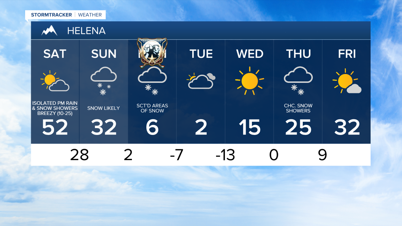
We are going to have increasing wind throughout the night tonight. It is then going to be very windy tomorrow along the Rocky Mountain Front as sustained wind speeds are going to be between 30 and 50 mph, and wind gusts up to 75+ mph are going to be possible at times. For locations east of the Rocky Mountain Front, it is going to be windy tomorrow as sustained wind speeds are going to be between 15 and 35 mph, and wind gusts over 50 mph are going to be possible at times. Mild temperatures are also expected tomorrow as highs are going to be in the mid to upper 40s and low to mid 50s in most locations.
During the day tomorrow, we are going to have partly to mostly cloudy skies. Along the Continental Divide and the Rocky Mountain Front, snow is going to develop throughout the day tomorrow. For locations east of the Rocky Mountain Front, a few rain and snow showers are possible tomorrow afternoon and evening, but a lot of locations are going to remain dry.
There are then going to be scattered areas of snow around tomorrow night as a cold front begins to pass through our area. Some rain is also possible with the initial onset of precipitation. Locations along the Hi-Line will see this precipitation first, while locations south of the Hi-Line will see this precipitation later on in the night. Widespread light to moderate snow is then expected throughout the day on Sunday, and some of this snow is going to stick around into Presidents’ Day on Monday.
In the lower elevations, 2 to 7 inches of snow accumulation is expected between Saturday evening and Monday morning. In the higher elevations, 6 to 12+ inches of snow accumulation is expected between Saturday evening and Monday morning. Even higher snowfall amounts are expected along the northern part of the Rocky Mountain Front (western Glacier County and western Pondera County), as 6 to 12 inches of snow accumulation is expected in the lower elevations between Saturday morning and Monday morning, and 1 to 2 feet of snow accumulation is expected in the higher elevations between Saturday morning and Monday morning.
This snow is going to create difficult travel conditions in the lower elevations, and very difficult to nearly impossible travel conditions in the Glacier National Park and northern Rocky Mountain Front area. If possible, try and limit non-essential travel from Saturday evening through Monday morning.
To go along with the snow, we are also going to have falling temperatures throughout the day on Sunday as the temperatures are going to be in the 20s and 30s just after midnight and will fall all the way down into the single digits and teens by Sunday afternoon. It is also going to be breezy Saturday night and Sunday, so subzero wind chills are possible, and blowing and drifting snow is also possible.
It is then going to be extremely cold on Monday as highs are only going to be in the single digits above and below zero, and wind chills are likely going to be in the teens and 20s below zero for a lot of the day.
By Tuesday, most of the snow is going to be gone, but the cold is still going to be here as highs on Tuesday are likely going to be below zero in a lot of locations, and wind chills are going to be in the teens and 20s below zero for a lot of the day. Tuesday night is then going to be dangerously cold as lows are going to be in the teens and 20s below zero, and wind chills as low as 40, even 50 below zero are possible.
A warming trend is then expected for the middle and end of next week as highs on Wednesday are going to be in the single digits and teens; highs on Thursday are going to be in the teens and 20s; and highs on Friday are going to be in the 20s and low to mid 30s. There is also going to be a little bit of a breeze around on each of these days as sustained wind speeds are going to be between 5 and 20 mph. We are also going to have mostly sunny skies on Wednesday and Friday, and we are going to have mostly cloudy skies with a chance of snow showers on Thursday.