


There have been scattered showers and thunderstorms around in Montana yesterday and today as a storm system has been impacting the state. For the most recent update on rainfall totals over the past two days in north-central Montana, head here: https://www.krtv.com/weather/rain-totals-july-21-2025
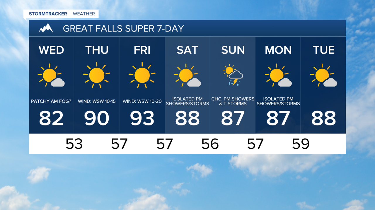
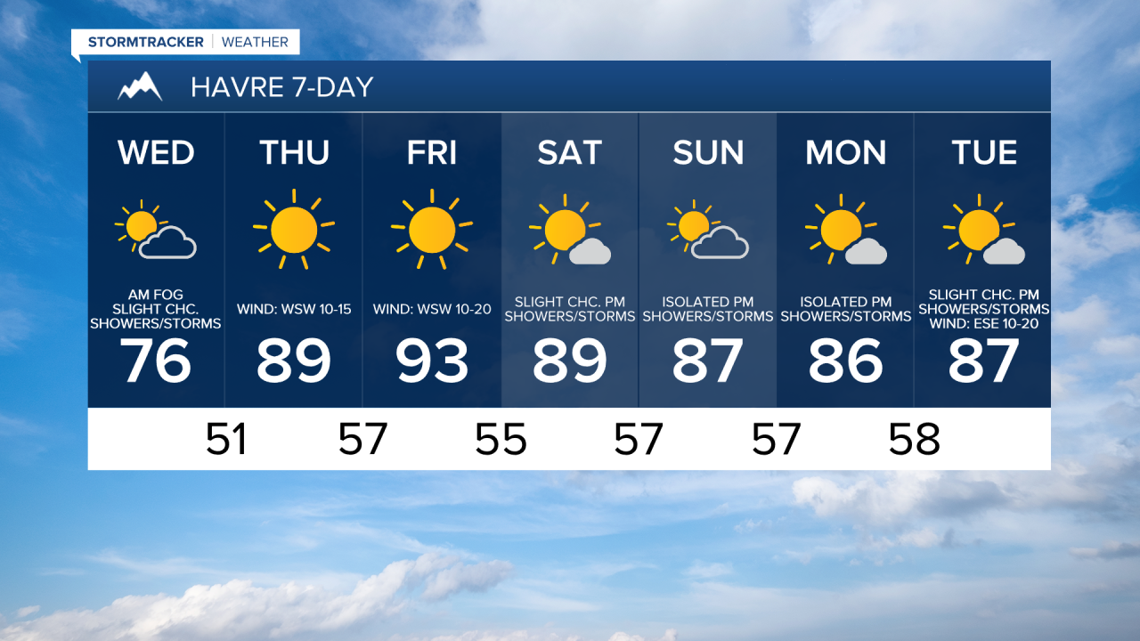
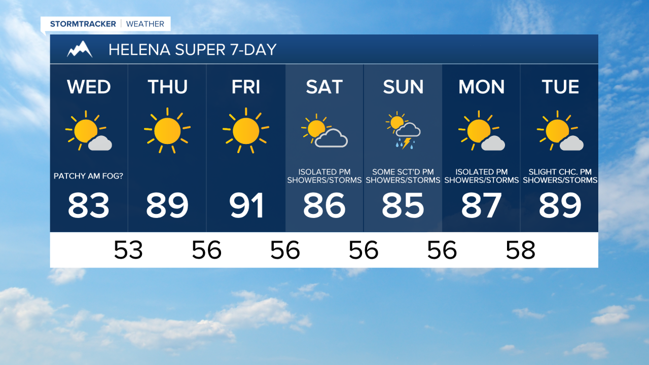
There will continue to be some scattered showers and thunderstorms around this evening and tonight, especially before midnight, as this storm system continues to impact our area. We are also going to have partly to mostly cloudy skies tonight with some areas of fog developing after midnight. Lows tonight will be in the mid to upper 40s and low to mid 50s.
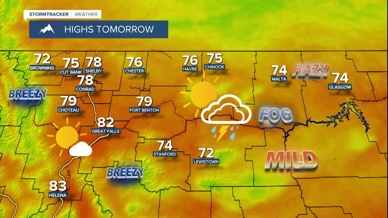
We are going to start tomorrow off with a lot of cloud cover and areas of fog, some of which may be dense. As we go through tomorrow, the fog will burn off and the skies will gradually clear out, providing us with partly to mostly sunny skies for the afternoon and evening. A lot of locations will be dry tomorrow, but there will be a few scattered showers and thunderstorms around, mainly east of a line from Havre to Stanford. It is also going to be warmer tomorrow than it was today as highs are going to be in the 70s and low 80s. There is also going to be a bit of a breeze around tomorrow along the Rocky Mountain Front as sustained wind speeds are going to be between 10 and 20 mph. Elsewhere, there is going to be little to no wind tomorrow.
There is also going to be some haze around tonight and tomorrow along the eastern half of the Hi-Line (Blaine County eastward to the North Dakota state line) as some Canadian wildfire smoke returns to the state. This haze/smoke won’t be as thick as what we had last night into this morning, but the air quality may still be unhealthy for sensitive groups in some locations later tonight and tomorrow morning.
Typical July weather will return for Thursday and Friday as we are going to have lots of sunshine, mainly dry conditions, and hot temperatures as highs are going to be in the mid to upper 80s and low to mid 90s. It is also going to be breezy on these two days along the Rocky Mountain Front as sustained wind speeds are going to be between 10 and 25 mph, and wind gusts up to 40 mph are possible. East of the Rocky Mountain Front, it is going to be a little breezy on Thursday as sustained wind speeds are going to be between 5 and 20 mph, and it is going to be breezy in some areas on Friday as sustained wind speeds are going to be between 10 and 20 mph.
It will continue to be very warm this weekend as highs are going to be in the 80s in most locations. On Saturday, we are going to have partly to mostly sunny skies via increasing clouds with a few showers and thunderstorms around during the afternoon and evening, generally in the mountains and in locations east of I-15. We are then going to have partly cloudy skies on Sunday with some scattered showers and thunderstorms around during the afternoon and evening, especially in the mountains.
Some more scattered showers and thunderstorms are possible Monday afternoon/evening, generally in the mountains and in locations east of I-15, and there are going to be a few isolated showers and thunderstorms around Tuesday afternoon/evening as we remain in an active weather pattern. We are also going to have mostly sunny skies and warm temperatures on these two days as highs are going to be in the 80s in most locations.