Compared to the past few days, the weather was much quieter today as the severe weather and most of the showers and thunderstorms remained south of Highway 200. For a recap of the severe weather over the past few days, head here: https://www.krtv.com/news/montana-and-regional-news/weekend-storms-rock-parts-of-montana
There will continue to be some isolated showers and thunderstorms around in central Montana this evening and early tonight, but most locations will be dry. We are also going to have partly cloudy skies and pleasant temperatures tonight as lows are going to be in the mid to upper 40s and low to mid 50s.
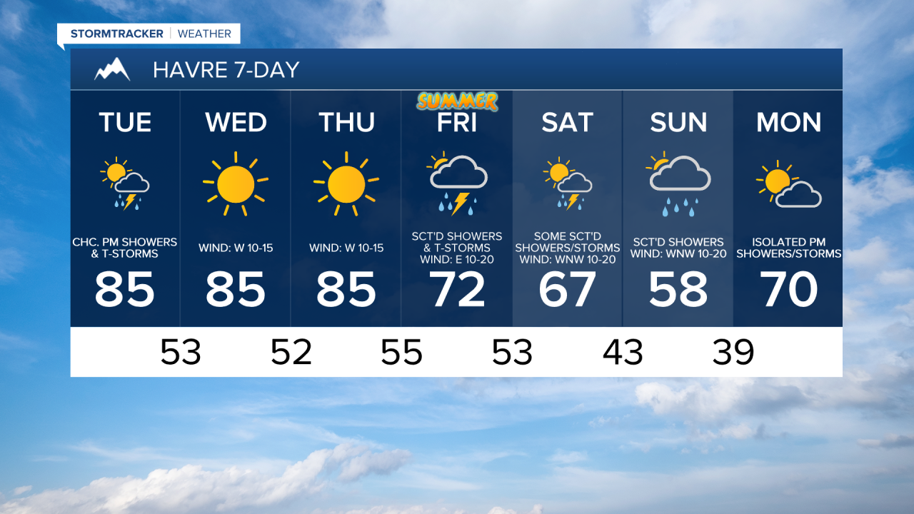
For tomorrow, we are going to have partly to mostly sunny skies with some scattered PM showers/storms in locations east of I-15. Around and west of I-15, it will be mainly dry tomorrow. It is also going to be mild/warm tomorrow as highs are going to be in the mid to upper 70s and low to mid 80s. There is also going to be a breeze around tomorrow along the Rocky Mountain Front and the Divide as sustained wind speeds are going to be between 10 and 20 mph.
We are then going to have beautiful summer-like weather on Wednesday and Thursday as an upper-level ridge is going to be in control of our weather. On Wednesday, we are going to have lots of sunshine and dry conditions, and on Thursday, we are going to have mostly sunny skies with just isolated PM showers and thunderstorms around, generally in the mountains. It is also going to be warm and a bit breezy on these two days as highs are going to be in the 80s and upper 70s, and sustained wind speeds are going to be between 10 and 20 mph (10-25 mph along the Rocky Mountain Front on Wednesday).
There are then going to be showers and thunderstorms around on Friday as a disturbance impacts our area, and some of these thunderstorms may be severe with damaging winds and/or large hail. It is also going to be cooler and a bit breezy on Friday as highs are going to be in the mid to upper 60s and low to mid 70s, and sustained wind speeds are going to be between 10 and 20 mph.
Wetter and cooler weather is expected this weekend as an upper-level trough is going to be in control of our weather. There are going to be scattered showers and some thunderstorms around on Saturday, and there are going to be scattered showers, isolated thunderstorms, and some mountain snow around on Sunday. We are also going to have partly to mostly cloudy skies on Saturday and mostly cloudy skies on Sunday. The temperatures are also going to cool down a lot this weekend as highs are going to be in the upper 50s, 60s, and low 70s on Saturday and the 50s on Sunday. There is also going to be a breeze around in some areas this weekend as sustained wind speeds are going to be between 10 and 20 mph.
The cooler temperatures won’t last long as highs will be back in the mid to upper 60s and low 70s on Monday. We are also going to have partly cloudy skies on Monday with a chance of PM showers and thunderstorms.